 Search: agricultural
Filter: Community of Granville
Search: agricultural
Filter: Community of Granville

| Date: | 1940 |
|---|---|
| Description: | This map of Granville visually shows different types of zones: agricultural areas, "A" residence, "B" residence, local businesses, commercial and light man... |
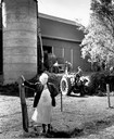
| Date: | 1954 |
|---|---|
| Description: | Mrs. Mary Shaughnessy standing in front of barn where men are loading the silo. Her farm was on the site where Granville School was later built. |
If you didn't find the material you searched for, our Library Reference Staff can help.
Call our reference desk at 608-264-6535 or email us at: