Search: airports
Filter: Subject of transportation
Search: airports
Filter: Subject of transportation

| Date: | 1950 |
|---|---|
| Description: | A map from the Wisconsin identifying the locations airports and other landing facilities in the state. On the opposite side the map includes an alphabetica... |
| Date: | 1950 |
|---|---|
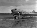
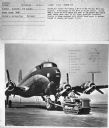
| Description: | Subject: "Airports — I-9." Where Taken: "MidW." Information with photograph reads: "Northwest Airline's I-9 towing a DC-4 at the Chicago Municipal Airport.... |
| Date: | 1950 |
|---|---|
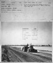
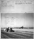
| Description: | View towards a man driving a tractor to compact a runway. Subject: "Airports — I-9." Where Taken: "MidW." Information with photograph reads: "I-9 and Bros ... |
| Date: | 1950 |
|---|---|
| Description: | Elevated view of a man driving a tractor to compact a runway. Subject: "Airports — I-9." Where Taken: "MidW." Information with photograph reads: "I-9 and B... |
| Date: | 1950 |
|---|---|
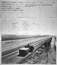
| Description: | View towards a man driving a tractor to compact a runway. There is an airplane on the runway in the background. Subject: "Airports — I-9." Where Taken: "Mi... |

| Date: | 02 1956 |
|---|---|
| Description: | This 1956 map of Waukesha County, Wisconsin, shows the township and range grid, towns, sections, cities and villages, roads, railroads, dams, airports, par... |
| Date: | 1950 |
|---|---|
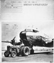
| Description: | Subject: "Airports — T-6 Tractor." Where Taken: "MidW." Information with photograph reads: "United Air Lines' T-6 towing a DC-6 at the Chicago Municipal Ai... |

| Date: | 1946 |
|---|---|
| Description: | A map showing the roads, railroads, towns, cities and villages, streams and lakes, airports, schools, churches, cemeteries, and golf courses in Kenosha Cou... |

| Date: | 1969 |
|---|---|
| Description: | This map shows ski areas, resorts, camps, special areas, airports, and roads. The map covers Vilas and Oneida counties and parts of Iron, Price, Lincoln, L... |

| Date: | 1960 |
|---|---|
| Description: | This map shows U.S. highways, state highways, county highways, town roads, county parks, county highway buildings, waysides, rivers, lakes, airports, a civ... |

| Date: | 1955 |
|---|---|
| Description: | This map shows roads, golf courses, airports, fire towers, schools, camp grounds, rivers, streams, lakes, and railroads. The right margin of the map includ... |

| Date: | 1962 |
|---|---|
| Description: | This map shows roads, golf courses, ski areas, boat landings, camp sites, waysides, parks, beaches, scenic views, virgin timber tracts, airports, boys and ... |

| Date: | 05 05 1932 |
|---|---|
| Description: | The U.S. airmail radio operator at Royal Airport in Madison. During the 1920s Madison had two airports: the Madison Airport (aka the North Street Airport) ... |

| Date: | 1962 |
|---|---|
| Description: | This map shows roads, golf courses, ski areas, boat landings, camp sites, waysides, parks, beaches, scenic views, virgin timber tracts, airports, boys and ... |
| Date: | 1948 |
|---|---|
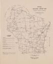
| Description: | This map shows the various locations of airports in the state of Wisconsin. Includes a legend of symbols in the lower left hand corner. Lake Michigan is on... |

| Date: | |
|---|---|
| Description: | Howard Morey (left) was associated with most of the airports in Madison. Prior to World War II he managed Madison Municipal Airport and when the military t... |

| Date: | 1938 |
|---|---|
| Description: | This map shows roads, parks, golf courses, airports, beaches, docks and harbors, lighthouses, and buoys within Winnebago County and parts of Waushara, Calu... |

| Date: | 1969 |
|---|---|
| Description: | This Post Office Department map identifies post offices, summer post offices, rural stations, highway post offices, Post Office sectional centers, rural de... |

| Date: | 1987 |
|---|---|
| Description: | This 1987 map of Racine and Kenosha counties, Wisconsin, shows towns, sections, cities and villages, zip code boundaries, highways and roads, bicycle route... |
If you didn't find the material you searched for, our Library Reference Staff can help.
Call our reference desk at 608-264-6535 or email us at: