Search: apostle
Search: islands
Filter: Subject of land
Filter: Subject of madeline island (wis.)
Search: apostle
Search: islands
Filter: Subject of land
Filter: Subject of madeline island (wis.)

| Date: | 08 1971 |
|---|---|
| Description: | Aerial view of Madeline Island, and a few of the Apostle Islands in the distance. |
| Date: | |
|---|---|
| Description: | Postcard of the "Vessel's Stern and Rudder Post" geological formation on Madeline Island, one of the Apostle Islands. View of the shoreline and a man sitti... |

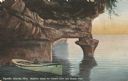
| Date: | 1880 |
|---|---|
| Description: | This copy of an 1834 map in the American Fur Company's papers held by the New-York Historical Society shows an outline of Chequamegon Bay and Madeline Isla... |

| Date: | 1834 |
|---|---|
| Description: | This copy of an 1834 map in the American Fur Company's papers held by the New-York Historical Society shows an outline of Chequamegon Bay and Madeline Isla... |
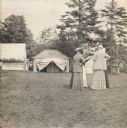
| Date: | 1915 |
|---|---|
| Description: | Women standing at General Fifield's Camp Stella at Sand Island, Apostle Island, Lake Superior. |
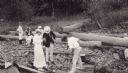
| Date: | 1914 |
|---|---|
| Description: | Group of people on an Apostle Island log-strewn beach. Outing included Johnie Webb, Mrs. Webb, Herbert Turman and Herbert Rogers. |
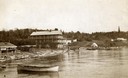
| Date: | 1890 |
|---|---|
| Description: | Old Mission Inn and boats on shoreline of Lake Superior on Madeline Island. The Old Mission Inn had numerous modifications over the years. It was razed in... |
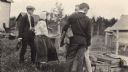
| Date: | 1910 |
|---|---|
| Description: | Three young men and a girl standing at South Shore Farm located on an Apostle Island. |
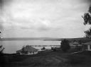
| Date: | |
|---|---|
| Description: | View of cottages and Mission dock on Lake Superior on Madeline Island. |
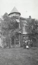
| Date: | 1910 |
|---|---|
| Description: | Group of people standing in front of Cedar Bark Lodge on (Wilson) Hermit Island, Apostle Islands. Cedar Bark Lodge was also known as the Hermitage. |

| Date: | 1847 |
|---|---|
| Description: | This map identifies surveyed areas of the Upper Peninsula and shows lakes, rivers, and islands in portions of Wisconsin, Minnesota, Michigan, and upper Can... |
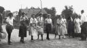
| Date: | 07 04 1922 |
|---|---|
| Description: | Women participating in egg race game during 4th of July celebration on Madeline Island, Apostle Island. Included are ?,?, Harriet Webb, Peg Caswell and Dor... |

| Date: | 1910 |
|---|---|
| Description: | Mrs. Elizabeth Lathrop sitting on steps of La Point Post Office with an unidentified woman. |
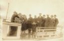
| Date: | 1920 |
|---|---|
| Description: | Group of people standing on board a passenger ferry bound for a New Year's trip to Ashland. |
| Date: | 1930 |
|---|---|
| Description: | Cyanotype view of Mrs. Harford sitting in pumpkin and corn in her garden on Madeline Island. |

| Date: | 1934 |
|---|---|
| Description: | Tree-lined dirt road curving along Madeline Island. |
| Date: | 1934 |
|---|---|
| Description: | View from water of footbridge crossing lagoon at Big Bay on Madeline Island. |
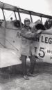
| Date: | 1919 |
|---|---|
| Description: | Clarence Russell leaning next to a Jenny bi-plane, wearing aviator gear. This was the first airplane to land on Madeline Island. |
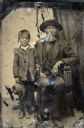
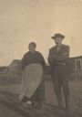
| Date: | 1854 |
|---|---|
| Description: | Tintype of Michael De Perry and unidentified child. |
If you didn't find the material you searched for, our Library Reference Staff can help.
Call our reference desk at 608-264-6535 or email us at: