Search: apostle
Search: islands
Filter: Subject of superior, lake
Search: apostle
Search: islands
Filter: Subject of superior, lake

| Date: | 1947 |
|---|---|
| Description: | This map shows the territories of Chippewa, Sioux, Winnebago, and Monomone tribes. It also shows navigation notes for rivers and lakes, Indian villages, hi... |
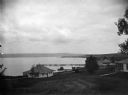
| Date: | |
|---|---|
| Description: | View of cottages and Mission dock on Lake Superior on Madeline Island. |

| Date: | 1847 |
|---|---|
| Description: | This map identifies surveyed areas of the Upper Peninsula and shows lakes, rivers, and islands in portions of Wisconsin, Minnesota, Michigan, and upper Can... |

| Date: | 1913 |
|---|---|
| Description: | Captain Dan Angus standing on wooden boat dock, smoking a cigar. Dr. Albert Gregory Hull is partially visible on the left. The boat dock is possibly on Dev... |
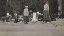
| Date: | 1918 |
|---|---|
| Description: | Picnic on Michigan Island beach at Apostle Island, Lake Superior. From left to right are Mrs. Chute, Mrs. Webb, Fritzie Chute (F.H. Chute, Minnepolis), A.G... |
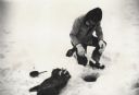
| Date: | |
|---|---|
| Description: | Man ice fishing on Chequamegon Bay through a hole with a fishing jig, fish and fry pan. |
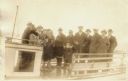
| Date: | 1920 |
|---|---|
| Description: | Group of people standing on board a passenger ferry bound for a New Year's trip to Ashland. |

| Date: | 08 1971 |
|---|---|
| Description: | View across water towards two seagulls resting on a rock outcropping of Stockton Island. Trees are growing on the top of the formation. |
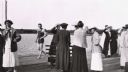
| Date: | 1910 |
|---|---|
| Description: | Group of ladies on Mission Dock, and "Ollie" Wilson in bathing suit walking by. Ladies identified as Mrs. N.J. Ross (shielding eyes) and Loretta Salmon in ... |

| Date: | 1930 |
|---|---|
| Description: | Large group of fishermen standing on ice with catch of fish displayed on airplane wing near La Pointe, Madeline Island. |
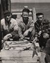
| Date: | 1955 |
|---|---|
| Description: | Catch of lake trout displayed by three fisherman on the pier at Little Sand Bay. From left to right are Martin Johnson, Hermy Johnson, and Myron Lohman. |
| Date: | 1934 |
|---|---|
| Description: | Man on Madeline Island cliff overlooking Lake Superior. |
| Date: | |
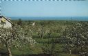
|---|---|
| Description: | Elevated view of an orchard during apple blossom season, with Lake Superior in the distance. |
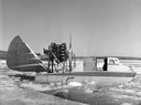
| Date: | 1955 |
|---|---|
| Description: | This was the first boat & sled-type wind sled built on Madeline Island. Built by Elmer Nelson for Howard Russell between 1950-1951. Had a 9-cylinder R-680-... |
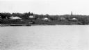
| Date: | 1910 |
|---|---|
| Description: | View from water of Mission cottages along shoreline of Lake Superior in La Pointe, Madeline Island. |
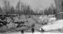
| Date: | 1934 |
|---|---|
| Description: | Three men standing on frozen Lake Superior in front of ice covered shoreline. |
| Date: | 1934 |
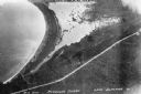
|---|---|
| Description: | Aerial view of Big Bay on Madeline Island. This area later became Big Bay State Park. |

| Date: | |
|---|---|
| Description: | Two women and a man are walking down the dock near a boat named "Chippewa" on Rocky Island.c South Twin Island is across the water in the background. |
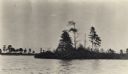
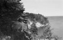
| Date: | 1915 |
|---|---|
| Description: | Trees on the eastern shoreline of Madeline Island near Big Bay. |
If you didn't find the material you searched for, our Library Reference Staff can help.
Call our reference desk at 608-264-6535 or email us at: