 Search: barns
Search: theresa
Search: township
Filter: Categories of Wisconsin Historical Images
Filter: Subject of weather
Search: barns
Search: theresa
Search: township
Filter: Categories of Wisconsin Historical Images
Filter: Subject of weather

| Date: | |
|---|---|
| Description: | View of farmland featuring farmhouses, barns, and a water tower. |

| Date: | |
|---|---|
| Description: | View of rows of field crops surrounded by other farmland. |
| Date: | 02 02 1978 |
|---|---|
| Description: | "Water tower view, looking due west." |
| Date: | 02 02 1978 |
|---|---|
| Description: | "Water tower view, looking to the east." |
| Date: | 03 1975 |
|---|---|
| Description: | "After the ice storm it was a mess on Doyle Road." |

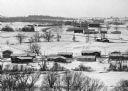
| Date: | 11 1995 |
|---|---|
| Description: | "This view of Hwy 175 looks south with the barn of Hans Rahjes in the upper left." |
| Date: | 02 02 1978 |
|---|---|
| Description: | "The camera looks to the new subdivision and beyond." |
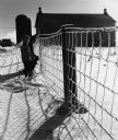
| Date: | 1968 |
|---|---|
| Description: | "Brenda & Kay Widmer examine an ice covered fence on the Jim Dobbe Farm (Sunny Brae Farm)." |
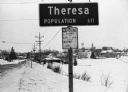
| Date: | 02 01 1978 |
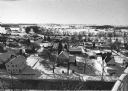
|---|---|
| Description: | "In the early morning hours, a new month dawns on the small village of Theresa. The village is now in the 130th year of its existence." The village marke... |

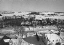
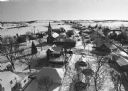
| Date: | 01 1983 |
|---|---|
| Description: | "This photo of Theresa was taken from the Ralph Bodden farm. The long 500mm mirror lens compresses the distance from the Paul Koll farm in the foreground t... |

| Date: | 01 1983 |
|---|---|
| Description: | "This photo of Theresa was taken from the Ralph Bodden farm. The long 500mm mirror lens compresses the distance from the Paul Koll farm in the foreground t... |

| Date: | 01 1983 |
|---|---|
| Description: | "This photo shows the John Steger home on the West Bend Road, foreground, the Willard Bogenschneider farm in the middle distance, and Theresa Station and t... |

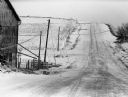
| Date: | 1962 |
|---|---|
| Description: | "This is Doyle Road, looking north, near where it intersects with Allen Road." Taken through the windsheild of the photograhper's car. |

| Date: | 1975 |
|---|---|
| Description: | "This photo was taken on McArthur Road. The present day River View Mobile Home Park is now on the right side in the picture." |
| Date: | 02 02 1978 |
|---|---|
| Description: | "A view from the water tower, looking due south. Groundhog Day was a cloud-free day; forecasting six more weeks of bad weather." |

| Date: | 02 16 1978 |
|---|---|
| Description: | "The long lens compresses this view from the frozen Rock River in the foreground, the Catholic cemetery, and the Haag farm buildings in the distance." |

| Date: | 1968 |
|---|---|
| Description: | "Brenda Widmer walks her dog Bonnie next to the disposal system. In distance is Sunny Brae farm, site of present-day Schnitzler River View Hills mobile hom... |
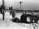
| Date: | 03 1975 |
|---|---|
| Description: | "As a result of the storm some farms did not have electricity for five days. A generator was shared by many farmers and was moved from farm to farm so that... |
If you didn't find the material you searched for, our Library Reference Staff can help.
Call our reference desk at 608-264-6535 or email us at:
