 Search: bird's
Search: eye
Search: ashland
Filter: Categories of Wisconsin Historical Images
Filter: Subject of transportation
Search: bird's
Search: eye
Search: ashland
Filter: Categories of Wisconsin Historical Images
Filter: Subject of transportation

| Date: | 1886 |
|---|---|
| Description: | Bird's-eye view of Ashland, on the shores of Lake Superior, with insets of The Apostle Islands Chequamagon Bay & Ashland, and Distances from Ashland. |

| Date: | 02 26 1887 |
|---|---|
| Description: | Bird's-eye map of Ashland, and the Apostle Islands in Lake Superior. Caption reads: "Ashland and the Apostle Islands." |

| Date: | 1890 |
|---|---|
| Description: | Bird's-eye map of Ashland, viewed from Lake Superior, with insets of Prentice Park and Fishery. Population 16,000. Increase in Ten Years, 11,000. |

| Date: | 1910 |
|---|---|
| Description: | Elevated view of a train yard with six sets of railroad tracks and large wooden buildings. A nearby neighborhood is visible in the background. Caption read... |

| Date: | |
|---|---|
| Description: | Looking West from Knight Block, with shipping piers and sailing ships on right side, railroad on left, trees in background. Horse-drawn carriages on street... |
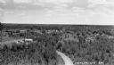
| Date: | 1932 |
|---|---|
| Description: | Elevated view overlooking Mercer. Roads, trees and buildings are visible. |
If you didn't find the material you searched for, our Library Reference Staff can help.
Call our reference desk at 608-264-6535 or email us at: