Search: bird's
Search: eye
Filter: Categories of Wisconsin Historical Images
Search: bird's
Search: eye
Filter: Categories of Wisconsin Historical Images
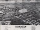
| Date: | 1882 |
|---|---|
| Description: | Bird's-eye map of Poynette, with one vignette. |
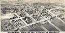
| Date: | 1877 |
|---|---|
| Description: | Bird's-eye map of Mondovi. |

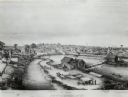
| Date: | 1874 |
|---|---|
| Description: | Bird's-eye map of Reedsburg, on the Baraboo River. |

| Date: | 1881 |
|---|---|
| Description: | Bird's-eye view of Appleton. |

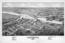
| Date: | 1905 |
|---|---|
| Description: | View towards river. Caption reads: "Bird's Eye View, Beloit, Wis." |

| Date: | 1880 |
|---|---|
| Description: | Bird's-eye view of Jefferson on the Rock River. |

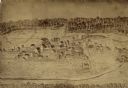
| Date: | 1876 |
|---|---|
| Description: | Bird's-eye view of Black Earth. |

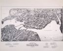
| Date: | 1906 |
|---|---|
| Description: | Bird's-eye map of South Milwaukee. |

| Date: | 1883 |
|---|---|
| Description: | Bird's-eye map of Manitowoc. |

| Date: | 1868 |
|---|---|
| Description: | Bird's-eye map of Manitowoc, with four insets. Manitowoc County. |

| Date: | 1875 |
|---|---|
| Description: | Bird's-eye map of Mazomanie. |
If you didn't find the material you searched for, our Library Reference Staff can help.
Call our reference desk at 608-264-6535 or email us at: