 Search: campaign
Filter: Subject of rivers
Search: campaign
Filter: Subject of rivers
| Date: | 1866 |
|---|---|
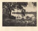
| Description: | Trees with Spanish moss along the Savannah River. Plate 47 |
| Date: | 1866 |
|---|---|
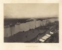
| Description: | Elevated view over storefronts and the river. Plate 50 |
| Date: | 1866 |
|---|---|
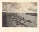
| Description: | Elevated view over storefronts and the river. Plate 49 |

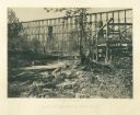
| Date: | 1866 |
|---|---|
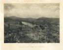
| Description: | The south bank of the Chattahoochie River with a bridge spanning it. In the foreground are some battlements. Plate 33 |
| Date: | 1866 |
|---|---|
| Description: | View towards the Allatoona Pass from behind earthworks overlooking the Etawah River. A railroad bridge crosses the river on the right. Plate 24 |
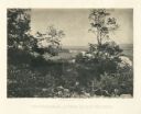
| Date: | 1866 |
|---|---|
| Description: | Elevated view of the Chattanooga Valley, with a river in the far background. A cliff face and trees are in the foreground. Plate 14 |

| Date: | 1866 |
|---|---|
| Description: | View along earthworks overlooking the Etawah River and a railroad bridge. A tree stripped of branches and bark is on the left. Plate 23 |

| Date: | 1866 |
|---|---|
| Description: | View of earthworks at the battlefield at Resacca. Dirt roads cross the field in the distance, leading to a farm and what appears to be a river. Plate 22... |
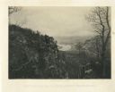
| Date: | 1866 |
|---|---|
| Description: | View of the Chattanooga Valley and a river from Lookout Mountain. Trees are in the foreground, and a city is in the background across the river. Plate 1... |
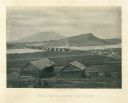
| Date: | 1866 |
|---|---|
| Description: | Two log buildings are in the foreground. A bridge spans a river in the middle distance, and the city of Chattanooga is on the far side at the base of a mou... |
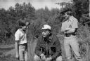
| Date: | 07 1974 |
|---|---|
| Description: | Nelson takes time out during a campaign trip to talk with two boys. Dressed casually, Nelson is shown squatting down in a marsh area between the boys who a... |

| Date: | 1864 |
|---|---|
| Description: | View down to valley of Union soldiers posing on the roof of a log building. A log bridge crosses a stream, and many trees are on the hillsides. Plate 05... |
| Date: | 1864 |
|---|---|
| Description: | View from shoreline of tall trestle bridge on the railroad line crossing the river at Whiteside. Two men sit on logs in the river on the left. More men sit... |

| Date: | 1862 |
|---|---|
| Description: | The second in a series of three maps of the Virginia Peninsula. This map details the area from Williamsburg north to West Point. |

| Date: | 1862 |
|---|---|
| Description: | The third in a series of three maps of the Virginia Peninsula. This map details the area from Harrison's Landing west to Richmond and shows troop positions... |

| Date: | 1950 |
|---|---|
| Description: | This map shows regions in Northern Illinois and Southern Wisconsin roughly bounded by Lake Winnebago, the Kankakee River, Peoria, and Prairie du Chien. The... |
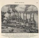
| Date: | 1887 |
|---|---|
| Description: | Engraving of Pittsburg Landing taken from a photograph a few days after the Battle of Shiloh (Tennessee), which occurred on April 6-7, 1862. The image sho... |

| Date: | 1795 |
|---|---|
| Description: | Map of the United States east of the Mississippi River. It features roads, cities, towns, early settlements, Native American land, forts, mountains, rivers... |

| Date: | 1780 |
|---|---|
| Description: | Detailed topographical and political map of the area from Lake Champlain to Albany and the Hudson River. Relief is shown through hachures. The map shows ci... |
If you didn't find the material you searched for, our Library Reference Staff can help.
Call our reference desk at 608-264-6535 or email us at: