 Search: catalog
Filter: Type of Map or Atlas
Search: catalog
Filter: Type of Map or Atlas

| Date: | 1985 |
|---|---|
| Description: | These blue line print maps include tables of road mileages with correction dates and labeled street, highways and railroad routes. The maps are labeled wit... |
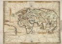
| Date: | 1513 |
|---|---|
| Description: | This exquisite woodcut map is one of the first to show any part of North America. It originally appeared in the 1513 Strasbourg edition of Ptolemy's Geogra... |
If you didn't find the material you searched for, our Library Reference Staff can help.
Call our reference desk at 608-264-6535 or email us at: