 Search: corporation
Filter: Type of Photograph
Filter: Subject of aerial photographs
Search: corporation
Filter: Type of Photograph
Filter: Subject of aerial photographs
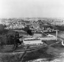
| Date: | 01 1973 |
|---|---|
| Description: | Aerial view of the Falk Corporation. Falk caption reads, "Black and white negatives, furnished to advertising department by J. Blank. See similar color pic... |
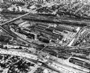
| Date: | 08 1975 |
|---|---|
| Description: | Original Falk description reads, "Latest aerial views of the main plant taken by Robert McCoy." |
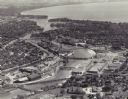
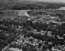
| Date: | 1955 |
|---|---|
| Description: | Aerial view of "the island" with the Marathon Corporation paper mills. The Fox River flowing out of Lake Winnebago separates the two cities, Neenah and Men... |

| Date: | 04 27 1951 |
|---|---|
| Description: | A composite map of the Madison area taken from aerial photos by Abrams Aerial Survey Corporation for the Madison Planning Commission. |
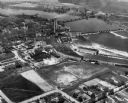
| Date: | 1948 |
|---|---|
| Description: | The Kimberly-Clark paper mill on the Fox River. |
| Date: | 07 1948 |
|---|---|
| Description: | The Kimberly-Clark paper mill on the Fox River, just east of Appleton. |
| Date: | 1948 |
|---|---|
| Description: | Aerial view of the Kimberly-Clark Paper Mill on the Fox River, just east of Appleton. |

| Date: | 10 30 1990 |
|---|---|
| Description: | Original Falk caption reads, "Aerial view [of] main plant (October 1990)." |

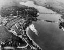
| Date: | |
|---|---|
| Description: | Aerial view of Marinette Harbor looking out towards Lake Superior. A lighthouse and breakwater extend out into the lake. Industrial buildings, cranes, and ... |

| Date: | 1945 |
|---|---|
| Description: | An aerial view, looking northeast, that includes the intersection at Atwood and Fair Oaks Avenues. Elmside Circle Park is on the bottom left. The Madison-K... |
If you didn't find the material you searched for, our Library Reference Staff can help.
Call our reference desk at 608-264-6535 or email us at: