 Search: historical
Filter: Categories of Wisconsin Historical Images
Filter: Community of Cedarburg
Search: historical
Filter: Categories of Wisconsin Historical Images
Filter: Community of Cedarburg
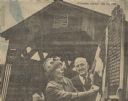
| Date: | 05 23 1965 |
|---|---|
| Description: | One of the last covered bridges in Wisconsin, located in Cedarburg, received an official state historical marker. The Last Covered Bridge historical marker... |
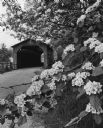
| Date: | 06 1969 |
|---|---|
| Description: | The Cedarburg Bridge, originally known as the Red Bridge, with a flowering tree on the right. Originally Wisconsin had more than 40 covered bridges. This i... |

| Date: | 1967 |
|---|---|
| Description: | This map of Cedarburg includes a list of historic buildings in the left margin. The map was created by the Ozaukee County Historical Society for Cedarburg'... |

| Date: | 1962 |
|---|---|
| Description: | View from side of road towards the covered bridge, with the historical marker on the right. "This bridge was built by the town of Cedarburg on petition of ... |

| Date: | 1872 |
|---|---|
| Description: | Wind powered stone grist mill. Two men stand on a wood balcony near the open doorway of the windmill. |
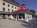
| Date: | 2008 |
|---|---|
| Description: | Alexander C. Eschweiler, a well-known architect in Milwaukee, designed this exotic station for the Wadhams Oil and Grease Company of Milwaukee in 1926. |
If you didn't find the material you searched for, our Library Reference Staff can help.
Call our reference desk at 608-264-6535 or email us at: