 Search: increase
Search: lapham
Filter: Categories of Wisconsin Historical Images
Filter: Community of Milwaukee
Search: increase
Search: lapham
Filter: Categories of Wisconsin Historical Images
Filter: Community of Milwaukee
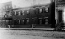
| Date: | 1900 |
|---|---|
| Description: | Exterior view of the home of Increase A. Lapham at 321-325 Poplar Street, which was built by J.A. Messenger in 1848. |
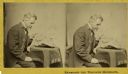
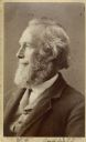
| Date: | 1868 |
|---|---|
| Description: | Stereograph of Increase Lapham examining a fragment of a meteorite. |

| Date: | |
|---|---|
| Description: | Map showing Indian mounds in Milwaukee's Second Ward from a sketch made by Increase Lapham in 1836. Streets shown on the map include 6th Street, 5th Street... |

| Date: | |
|---|---|
| Description: | Letterhead stationery featuring an engraving of the Milwaukee Iron Company foundry. The letter is from an officer of the company to noted geologist Increas... |

| Date: | 1846 |
|---|---|
| Description: | This map shows lot and block numbers, roads, railroads, and some landowners’ names and includes the manuscript annotations: "From the Lapham collection" --... |
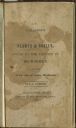
| Date: | 1836 |
|---|---|
| Description: | Title page of Increase Lapham's A catalog of Plants & Shells, Found in the vicinity of Milwaukee on the West Side of Lake Michigan, |
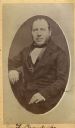
| Date: | |
|---|---|
| Description: | Carte-de-visite portrait of Franz Brandecke, Milwaukee-based geologist. Worked on Wisconsin geological survey with Lapham. Handwritten text on front read... |

| Date: | 1845 |
|---|---|
| Description: | This map shows lot and block numbers, local streets, railroads, some landowners’ names, Milwaukee River, Menomonee River, and part of Lake Michigan. The ma... |

| Date: | 1836 |
|---|---|
| Description: | Pencil on tracing paper. Rough sketch of Milwaukee. Left top corner reads: "From Map of northern part of Illinois and the surveyed part of Wisconsin Territ... |
| Date: | 07 22 1837 |
|---|---|
| Description: | Table printed in Milwaukee Advertiser indicating the time of flowering of several wild plants at Milwaukee and near the head of the Pishtaka River. |

| Date: | 1863 |
|---|---|
| Description: | Includes index to public buildings, churches, schools. Inset: Glidden & Lockwood’s addition. Gives names of some property owners. |

| Date: | 1848 |
|---|---|
| Description: | This map shows lot and block numbers, roads, railroads, and some landowners’ names. Lake Michigan, the Milwaukee River, and the Menomonee River are labeled... |
| Date: | 1870 |
|---|---|
| Description: | Carte-de-visite portrait of William H. Canfield (1819-1913), a Wisconsin civil engineer and surveyor who is best known for his studies of Sauk County's nat... |

| Date: | 1846 |
|---|---|
| Description: | This map shows lot and block numbers, local streets, railroads, some landowners’ names, Milwaukee River, Menomonee River, and part of Lake Michigan. The ma... |

| Date: | 1847 |
|---|---|
| Description: | This map shows lot and block numbers, roads, railroads, and some landowners’ names. Lake Michigan, the Milwaukee River, and the Menomonee River are labeled... |

| Date: | 1854 |
|---|---|
| Description: | This map shows lot and block numbers, roads, railroads, and some landowners’ names. Lake Michigan, the Milwaukee River, and the Menomonee River are labeled... |

| Date: | 1849 |
|---|---|
| Description: | This map shows lot and block numbers, wards, local streets, railroads, some landowners’ names, Milwaukee River, Menomonee River, and part of Lake Michigan.... |

| Date: | 1849 |
|---|---|
| Description: | This map shows lot and block numbers, wards, local streets, railroads, some landowners’ names, Milwaukee River, Menomonee River, and part of Lake Michigan.... |

| Date: | 1850 |
|---|---|
| Description: | Map showing Indian mounds and graves as well as ground cover types at Township 8, Range 22. There is an inset diagram of an effigy mound labeled "The Cross... |

| Date: | 1836 |
|---|---|
| Description: | This hand-colored manuscript map shows the township and section grid in southeastern Wisconsin, covering the area west to Sugar River and Four Lakes region... |
If you didn't find the material you searched for, our Library Reference Staff can help.
Call our reference desk at 608-264-6535 or email us at: