 Search: increase
Search: lapham
Filter: Categories of Wisconsin Historical Images
Filter: County of Jefferson
Search: increase
Search: lapham
Filter: Categories of Wisconsin Historical Images
Filter: County of Jefferson
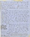
| Date: | 06 28 1850 |
|---|---|
| Description: | Letter from Increase Lapham to his wife, Ann Maria Alcott, in Milwaukee. Lapham was at Aztalan and wrote to Anna regarding the geology of the region. He in... |

| Date: | 1837 |
|---|---|
| Description: | Copy of N.F. Hyer's original map of Aztalan as published in the Milwaukee Advertiser, February 25, 1837. |

| Date: | 1840 |
|---|---|
| Description: | Map shows three Wisconsin territories, Jefferson, Waukesha, and Milwaukee. Map is ink, pencil, and watercolor on paper. Relief shown by hachures. |
| Date: | 1930 |
|---|---|
| Description: | View of the panther itaglio effigy mound marker, located on Highway 106 West. The text on the marker reads: "Panther Intaglio Effigy; Panther Type, Length ... |

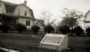
| Date: | 1936 |
|---|---|
| Description: | View of the panther intaglio effigy mound marker, located on Highway 106 West. The text on the marker reads: "Indian Intaglio Effigy; Panther Type, Length ... |
If you didn't find the material you searched for, our Library Reference Staff can help.
Call our reference desk at 608-264-6535 or email us at:
