 Search: increase
Search: lapham
Filter: Categories of Wisconsin Historical Images
Search: increase
Search: lapham
Filter: Categories of Wisconsin Historical Images

| Date: | 1840 |
|---|---|
| Description: | An ink, watercolor, and pencil on tracing paper, hand-drawn map of Milwaukee County, Wisconsin that shows the town and range system, sections, lakes and st... |
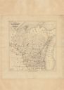
| Date: | 1870 |
|---|---|
| Description: | Carte-de-visite portrait of William H. Canfield (1819-1913), a Wisconsin civil engineer and surveyor who is best known for his studies of Sauk County's nat... |

| Date: | 1846 |
|---|---|
| Description: | This map shows lot and block numbers, local streets, railroads, some landowners’ names, Milwaukee River, Menomonee River, and part of Lake Michigan. The ma... |

| Date: | 1847 |
|---|---|
| Description: | This map shows lot and block numbers, roads, railroads, and some landowners’ names. Lake Michigan, the Milwaukee River, and the Menomonee River are labeled... |

| Date: | 1854 |
|---|---|
| Description: | This map shows lot and block numbers, roads, railroads, and some landowners’ names. Lake Michigan, the Milwaukee River, and the Menomonee River are labeled... |

| Date: | 1849 |
|---|---|
| Description: | This map shows lot and block numbers, wards, local streets, railroads, some landowners’ names, Milwaukee River, Menomonee River, and part of Lake Michigan.... |

| Date: | 1849 |
|---|---|
| Description: | This map shows lot and block numbers, wards, local streets, railroads, some landowners’ names, Milwaukee River, Menomonee River, and part of Lake Michigan.... |
| Date: | 1865 |
|---|---|
| Description: | This map shows county boundaries and the congressional districts outlined and numbered in color. Included are portions of Minnesota, Iowa, Illinois and Mic... |

| Date: | 1837 |
|---|---|
| Description: | This map shows the proposed Rock River Canal, between Milwaukee County thru the west line of what is now Waukesha County. Also shows townships, roads, hydr... |

| Date: | |
|---|---|
| Description: | Three separate maps: Ancient Works Near Manitowoc (surveyed 1850), Ancient Works on the North Side of Lake Wingra (surveyed 1850), and Mounds at Madison (s... |

| Date: | 1850 |
|---|---|
| Description: | Map showing Indian mounds and graves as well as ground cover types at Township 8, Range 22. There is an inset diagram of an effigy mound labeled "The Cross... |
| Date: | 1866 |
|---|---|
| Description: | Vignetted carte-de-visite portrait of Ezra S. Carr, geologist and California State Superintendent. He held chemistry professorships at various institution... |
| Date: | 1867 |
|---|---|
| Description: | Carte-de-visite portrait of George Engelmann (1809-1884), German-American botanist. He is best known for describing the flora of the American West. Handwr... |
| Date: | 09 29 1864 |
|---|---|
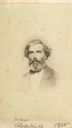
| Description: | Carte-de-visite portrait of William S. Sullivant (1803-1873), Ohio naturalist. Sullivant was one of the leading bryologists in the United States, focusing ... |
| Date: | 1865 |
|---|---|
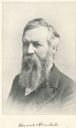
| Description: | Vignetted carte-de-visite portrait of Alexander Kerr (1828-1919), Scottish-born Professor of Greek at the University of Wisconsin-Madison. Appointed to his... |
| Date: | |
|---|---|
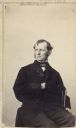
| Description: | Quarter-length carte-de-visite of Alexander Winchell (1824-1891), State Geologist of Michigan and Professor of Geology and Paleontology at the University o... |
| Date: | |
|---|---|
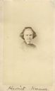
| Description: | Vignetted carte-de-visite portrait of Harriet Hosmer (1830-1908), Massachusetts-based sculptor. Handwritten inscription at bottom of card reads, "Harriet ... |

| Date: | 1852 |
|---|---|
| Description: | Map reads: "The State of Wisconsin- compiled from the latest authorities". In addition, there is a scale which is six miles for every inch, and a profile o... |

| Date: | 1866 |
|---|---|
| Description: | This thematic shows the effects that Lake Michigan has had on Wisconsin mean temperatures in January and July. The map shows counties, some cities, rivers ... |

| Date: | 1868 |
|---|---|
| Description: | This map of the entire state shows county boundaries outlined in red, cities of over 3000 inhabitants and county seats. It also marks rivers, lakes, railro... |
If you didn't find the material you searched for, our Library Reference Staff can help.
Call our reference desk at 608-264-6535 or email us at: