 Search: increase
Search: lapham
Filter: Reproduction Rights of For Sale
Search: increase
Search: lapham
Filter: Reproduction Rights of For Sale
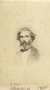
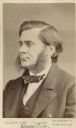
| Date: | 1865 |
|---|---|
| Description: | Vignetted carte-de-visite portrait of Alexander Kerr (1828-1919), Scottish-born Professor of Greek at the University of Wisconsin-Madison. Appointed to his... |
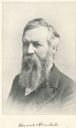
| Date: | |
|---|---|
| Description: | Quarter-length carte-de-visite of Alexander Winchell (1824-1891), State Geologist of Michigan and Professor of Geology and Paleontology at the University o... |
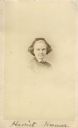
| Date: | |
|---|---|
| Description: | Vignetted carte-de-visite portrait of Harriet Hosmer (1830-1908), Massachusetts-based sculptor. Handwritten inscription at bottom of card reads, "Harriet ... |

| Date: | 1852 |
|---|---|
| Description: | Map reads: "The State of Wisconsin- compiled from the latest authorities". In addition, there is a scale which is six miles for every inch, and a profile o... |

| Date: | 1866 |
|---|---|
| Description: | This thematic shows the effects that Lake Michigan has had on Wisconsin mean temperatures in January and July. The map shows counties, some cities, rivers ... |

| Date: | 1868 |
|---|---|
| Description: | This map of the entire state shows county boundaries outlined in red, cities of over 3000 inhabitants and county seats. It also marks rivers, lakes, railro... |

| Date: | 1836 |
|---|---|
| Description: | This hand-colored manuscript map shows the township and section grid in southeastern Wisconsin, covering the area west to Sugar River and Four Lakes region... |

| Date: | 1838 |
|---|---|
| Description: | This manuscript map, drawn in pencil, shows the lakes and rivers in the area between Lake of the Woods in northern Minnesota, the Mississippi River on the ... |

| Date: | 1849 |
|---|---|
| Description: | Published a year after Wisconsin entered statehood, this map shows the counties and towns in existence at the time - mainly in southern/southeastern Wiscon... |

| Date: | 1851 |
|---|---|
| Description: | Map outlines mid and southern Wisconsin county boundaries in blue, and city/town lines are provided. Other marks include mines, plank roads, and railroads. |

| Date: | 1857 |
|---|---|
| Description: | This map shows the township survey grid and identifies counties, named towns, cities and villages, rivers, lakes, and railroads. Boundaries are shown in bl... |

| Date: | 1869 |
|---|---|
| Description: | This geological map shows the township grid, counties, cities and villages, rivers, lakes, railroads, and roads. Barron County is still labeled Dallas Coun... |

| Date: | 1861 |
|---|---|
| Description: | Map with labelled block and lot numbers, owners of large property parcels, city wards, railroads, and streets. Population from 1835 to 1860 listed below ti... |
| Date: | 1865 |
|---|---|
| Description: | Carte-de-visite portrait of James Dwight Dana (1813-1895), American minerologist, geologist, and zoologist. He is best known for his discoveries of mountai... |

| Date: | 1856 |
|---|---|
| Description: | This map shows lot and block numbers, wards, roads, railroads, and some landowner names. Lake Michigan and the Milwaukee River are labeled. Includes an ins... |

| Date: | 1855 |
|---|---|
| Description: | This map shows the locations of ancient works in the state of Wisconsin. Lake Superior and Michigan are labeled. Counties, towns, and rivers are also label... |
| Date: | 1863 |
|---|---|
| Description: | Carte-de-visite portrait of John Gould Anthony (1804-1877), head of the Conchology department at the Museum of Comparative Zoology from 1863 until his deat... |
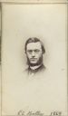
| Date: | 1864 |
|---|---|
| Description: | Carte-de-visite portrait of Edwin C. Bolles (1836-1920), professor of English and American History at Tufts. He is best known for amassing a vast archive o... |
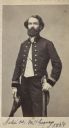
| Date: | 1864 |
|---|---|
| Description: | Carte-de-visite portrait of Professor Joseph H. McChesney, a geologist and paleontologist associated with the Illinois State Geological Survey. Shown here ... |
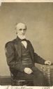
| Date: | 1874 |
|---|---|
| Description: | Carte-de-visite portrait of Thomas H. Huxley, an English biologist, known as "Darwin's Bulldog." He also coined the term "agnosticism" to describe his reli... |
If you didn't find the material you searched for, our Library Reference Staff can help.
Call our reference desk at 608-264-6535 or email us at: