 Search: increase
Search: lapham
Search: increase
Search: lapham
| Date: | 1864 |
|---|---|
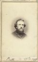
| Description: | Vignetted carte-de-visite portrait of William H. Pratt of Davenport, Iowa. Handwritten inscription at bottom reads, "Pratt, 1864." |
| Date: | |
|---|---|
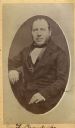
| Description: | Carte-de-visite portrait of Franz Brandecke, Milwaukee-based geologist. Worked on Wisconsin geological survey with Lapham. Handwritten text on front read... |

| Date: | 1921-11-15 |
|---|---|
| County: | Milwaukee |
| City: | Milwaukee |
| Date: | 1909-10-10 |
|---|---|
| County: | Milwaukee |
| City: | Milwaukee |

| Date: | 1864 |
|---|---|
| Description: | This map shows locations of quarries, sink holes, creeks, springs, rivers, houses, forts, and roads. The upper right corner and right margin includes anno... |
| Date: | 1916-07-08 |
|---|---|
| County: | Milwaukee |
| City: | Milwaukee |
| Date: | 1909-09-17 |
|---|---|
| County: | Milwaukee |
| City: | Milwaukee |
| Date: | 1927-01-23 |
|---|---|
| County: | Milwaukee |
| City: | Milwaukee |
| Date: | 1872 |
|---|---|
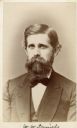
| Description: | Carte-de-visite portrait of Professor W.W. Daniels, University of Wisconsin geologist. Daniels worked as one of Increase Lapham's assistants during the Wis... |
| Date: | 12 1860 |
|---|---|
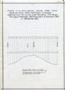
| Description: | Graph showing the profile of a semi-diurnal spring tidal curve deduced from 5452 half hourly ordinates obtained from the records of self registering tide g... |
| Date: | 1905-06-17 |
|---|---|
| County: | La Crosse |
| City: | La Crosse |
| Date: | 1914-12-08 |
|---|---|
| County: | Dane |
| City: | Madison |
| Date: | 1931-07-19 |
|---|---|
| County: | Milwaukee |
| City: | Milwaukee |

| Date: | 1864 |
|---|---|
| Description: | This map is pen and watercolor on paper and shows a profile and geological sections of the Apple River, Little Otter Creek, Woods' Branch, Bonners' Branch,... |

| Date: | 1864 |
|---|---|
| Description: | Map showing locations of quarries, sink holes, creeks, springs, rivers, houses, forts, and roads. The map appears to have been drawn on to of a plat map of... |
If you didn't find the material you searched for, our Library Reference Staff can help.
Call our reference desk at 608-264-6535 or email us at:

