 Search: increase
Filter: Categories of Wisconsin Historical Images
Filter: Creator Name of Lapham, Increase Allen
Search: increase
Filter: Categories of Wisconsin Historical Images
Filter: Creator Name of Lapham, Increase Allen

| Date: | |
|---|---|
| Description: | Map showing Indian mounds in Milwaukee's Second Ward from a sketch made by Increase Lapham in 1836. Streets shown on the map include 6th Street, 5th Street... |

| Date: | 1875 |
|---|---|
| Description: | This manuscript map by Increase Lapham, drawn in the last year of his life, shows landownership, roads and railroads, springs, and boat houses around Ocono... |

| Date: | 1840 |
|---|---|
| Description: | This manuscript map by Increase Lapham shows the railroads, roads, wetlands, lakes and streams, dams, prairies, and settlers in the eastern half of Waukesh... |
| Date: | 1850 |
|---|---|
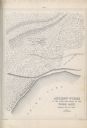
| Description: | A drawing of ancient works at the southeast angle of the Third Lake. |

| Date: | 1850 |
|---|---|
| Description: | Diagrams of four effigy mounds surveyed by Increase A. Lapham and W.H. Canfield in 1850. No. 1 is an unidentified animal shape, No. 2 consists of two linea... |
| Date: | 1832 |
|---|---|
| Description: | Page from the handwritten index to Lapham's Notes and accounts of canals, particularly the Ohio Canal near Portsmouth, 1830-1832. |
| Date: | 1827 |
|---|---|
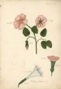
| Description: | Drawings of Datura Stramonium, more commonly known by the names jimson weed, devil's trumpet, devil's weed, thorn apple, tolguacha, Jamestown weed, stinkwe... |

| Date: | 1855 |
|---|---|
| Description: | This map by Increase Lapham shows the Penokee Iron Range in Ashland and Iron counties, Wisconsin. Part of the Gogebic Range, the Penokees extend from an ar... |

| Date: | 1866 |
|---|---|
| Description: | This manuscript map by Increase Lapham shows the Dells of the Wisconsin River, from Stand Rock and Witches Gulch at the north to a point approximately one ... |

| Date: | 1848 |
|---|---|
| Description: | This map by Increase Lapham shows the township and range system in southern and eastern Wisconsin as well as along the Wisconsin River in present-day Marat... |

| Date: | 1849 |
|---|---|
| Description: | Pencil sketch of a cross-section of the Dells of the Wisconsin River. People are in a row boat in the center. Caption at bottom: "The Dells — Wisconsin Riv... |

| Date: | 1836 |
|---|---|
| Description: | Pencil on tracing paper. Rough sketch of Milwaukee. Left top corner reads: "From Map of northern part of Illinois and the surveyed part of Wisconsin Territ... |
| Date: | 1846 |
|---|---|
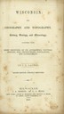
| Description: | Title page of the book "Wisconsin: Geography and Topography". |

| Date: | 1864 |
|---|---|
| Description: | This map is pen and pencil on paper and shows a profile of the Blue Mound and East Blue Mound. |

| Date: | 1864 |
|---|---|
| Description: | This map is pen and pencil on paper and shows a profile of the Blue Mound and East Blue Mound. |

| Date: | 1864 |
|---|---|
| Description: | This map is pen and watercolor on paper and shows a profile and the geological formation of Blue Mound. Also shown is the location of Arnold's Hotel and Br... |

| Date: | 1864 |
|---|---|
| Description: | This map shows locations of quarries, sink holes, creeks, springs, rivers, houses, forts, and roads. |

| Date: | 1867 |
|---|---|
| Description: | This 1867 manuscript map by Increase Lapham shows the topography and geology of the Blue Mounds region in the Town of Brigham in Iowa County and the towns ... |

| Date: | 1864 |
|---|---|
| Description: | This map shows locations of quarries, sink holes, creeks, springs, rivers, houses, forts, and roads. The upper right corner and right margin includes anno... |
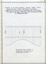
| Date: | 12 1860 |
|---|---|
| Description: | Graph showing the profile of a semi-diurnal spring tidal curve deduced from 5452 half hourly ordinates obtained from the records of self registering tide g... |
If you didn't find the material you searched for, our Library Reference Staff can help.
Call our reference desk at 608-264-6535 or email us at: