 Search: industry
Filter: Type of Map or Atlas
Search: industry
Filter: Type of Map or Atlas

| Date: | 1901 |
|---|---|
| Description: | Map shows lakes, rivers, schools, saw mills, post offices, creameries, and churches. Includes significant manuscript annotations showing township divisions... |

| Date: | 1885 |
|---|---|
| Description: | A detail of a Sanborn map showing the lake Mendota shore area, including Madison Manufacturing Company. |

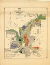
| Date: | 1918 |
|---|---|
| Description: | Map illlustrates creameries, condenseries and cheese factories in Wisconsin, January, 1918, and value of products. Five smaller maps in margin show changes... |

| Date: | 1892 |
|---|---|
| Description: | A Sanborn map of St. Louis, which is six miles southwest of South Superior. |

| Date: | 04 1901 |
|---|---|
| Description: | A Sanborn map of Watertown, including an index and a key. |

| Date: | 1915 |
|---|---|
| Description: | A Sanborn fire insurance map of Sauk City created in 1915. |

| Date: | 1885 |
|---|---|
| Description: | Fire insurance map of the McCormick Reaper Works, a factory of the McCormick Harvesting Machine Company. |

| Date: | 1892 |
|---|---|
| Description: | A Sanborn fire insurance map of Sauk City which was drawn up in 1892. |

| Date: | 1915 |
|---|---|
| Description: | A Sanborn fire insurance map of Sauk City created in 1915. |

| Date: | 1900 |
|---|---|
| Description: | A Sanborn fire insurance map of Sauk City created in 1900. |

| Date: | 1900 |
|---|---|
| Description: | Shows lands belonging to Wisconsin Timber and Land Co., towns, post offices, saw mills, creameries, camps, churches, schools, farm houses, town halls, rail... |
| Date: | 1956 |
|---|---|
| Description: | This map of Rhinelander shows lots, 6 types of zoning in various colors; heavy industry, light industry, commercial, residence "A," residence "unrated," lo... |

| Date: | 1908 |
|---|---|
| Description: | A detail of a Sanborn map showing the area around North Franklin, North Blair and North Hancock Streets. |

| Date: | 1874 |
|---|---|
| Description: | Bird's-eye map of Chippewa Falls. |

| Date: | 1923 |
|---|---|
| Description: | This blue line print map shows townships, landownership, roads, residences, churches, schools, town halls, saw mills, and cheese factories. Includes red ma... |
If you didn't find the material you searched for, our Library Reference Staff can help.
Call our reference desk at 608-264-6535 or email us at:


