Search: industry
Filter: Year of 1900-1999
Filter: Year of 1900-1909
Filter: Subject of church buildings
Search: industry
Filter: Year of 1900-1999
Filter: Year of 1900-1909
Filter: Subject of church buildings

| Date: | 1901 |
|---|---|
| Description: | Map shows lakes, rivers, schools, saw mills, post offices, creameries, and churches. Includes significant manuscript annotations showing township divisions... |

| Date: | 04 1901 |
|---|---|
| Description: | A Sanborn map of Watertown, including an index and a key. |

| Date: | 1900 |
|---|---|
| Description: | A Sanborn fire insurance map of Sauk City created in 1900. |

| Date: | 1900 |
|---|---|
| Description: | Shows lands belonging to Wisconsin Timber and Land Co., towns, post offices, saw mills, creameries, camps, churches, schools, farm houses, town halls, rail... |

| Date: | 1900 |
|---|---|
| Description: | Elevated view across canal. Along the shoreline are piles of lumber along the shipping dock. Men are working with horse-drawn vehicles among the stacks of ... |

| Date: | 1909 |
|---|---|
| Description: | A map of Langlade County, Wisconsin that shows townships and ranges, towns, cities and villages, wagon roads, churches, schools, sawmills, town halls, chee... |
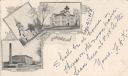
| Date: | 1903 |
|---|---|
| Description: | Postcard with three illustrations — the Cotton Mills, the First M.E. Church, and the High School. |

| Date: | 1900 |
|---|---|
| Description: | Elevated view across canal towards McCormick works. There are piles of parts along the shipping dock. A large church building is in the far distance. |

| Date: | 1908 |
|---|---|
| Description: | Elevated view of Glidden. The lumber mill is in the foreground. A church and a water tower are on the horizon. |

| Date: | 1905 |
|---|---|
| Description: | A view, looking east, of the grounds and buildings of the Montello Granite Company. On the left, a train car with "Detroit Southern" painted on it stands o... |
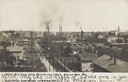
| Date: | 1905 |
|---|---|
| Description: | Caption reads: "Birds Eye View, from cotton mill tower, Beaver Dam, Wis." Two churches are in the background, and there are smokestacks and a water tower n... |

| Date: | 1905 |
|---|---|
| Description: | This early 20th century map of Door County, Wisconsin, shows the township and range grid, towns, sections, cities and villages, landownership and acreages,... |

| Date: | 1908 |
|---|---|
| Description: | Map shows townships and sections, landownership and acreages, rural routes, roads, railroads, creameries, churches, schools, and town halls. Sections appea... |

| Date: | 1909 |
|---|---|
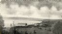
| Description: | Elevated view of the Baraboo River. The main part of town is on the far left shoreline. On the right industrial buildings are near a bridge spanning the ri... |

| Date: | 1902 |
|---|---|
| Description: | This map shows townships, land parcels, schools, rivers, lakes, creameries, churches, cemeteries, roads, post offices, town halls, saw mills, roads and sto... |

| Date: | 1900 |
|---|---|
| Description: | Elevated view across canal of the plant, with railroad boxcars behind a long, low industrial buildings along the far shoreline. Behind the railroad tracks ... |
If you didn't find the material you searched for, our Library Reference Staff can help.
Call our reference desk at 608-264-6535 or email us at: