Search: industry
Filter: Year of 1900-1999
Filter: Year of 1900-1909
Filter: Subject of education
Search: industry
Filter: Year of 1900-1999
Filter: Year of 1900-1909
Filter: Subject of education

| Date: | 1901 |
|---|---|
| Description: | Map shows lakes, rivers, schools, saw mills, post offices, creameries, and churches. Includes significant manuscript annotations showing township divisions... |

| Date: | 04 1901 |
|---|---|
| Description: | A Sanborn map of Watertown, including an index and a key. |

| Date: | 1900 |
|---|---|
| Description: | A Sanborn fire insurance map of Sauk City created in 1900. |

| Date: | 1900 |
|---|---|
| Description: | Shows lands belonging to Wisconsin Timber and Land Co., towns, post offices, saw mills, creameries, camps, churches, schools, farm houses, town halls, rail... |

| Date: | 1901 |
|---|---|
| Description: | Map shows townships, schools, creameries, post offices, and roads. The left side of the map features a legend with symbols for points of interest. |

| Date: | 1909 |
|---|---|
| Description: | A map of Langlade County, Wisconsin that shows townships and ranges, towns, cities and villages, wagon roads, churches, schools, sawmills, town halls, chee... |
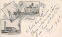
| Date: | 1903 |
|---|---|
| Description: | Postcard with three illustrations — the Cotton Mills, the First M.E. Church, and the High School. |

| Date: | 1905 |
|---|---|
| Description: | This early 20th century map of Door County, Wisconsin, shows the township and range grid, towns, sections, cities and villages, landownership and acreages,... |

| Date: | 1908 |
|---|---|
| Description: | Map shows townships and sections, landownership and acreages, rural routes, roads, railroads, creameries, churches, schools, and town halls. Sections appea... |
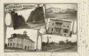
| Date: | 1905 |
|---|---|
| Description: | Photographic postcard of a collage of 5 views of Brandon including; Washington St., Public Square, Times Office, High School, and Depot & Park. |
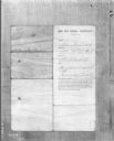
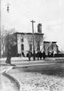
| Date: | 01 05 1907 |
|---|---|
| Description: | A photograph of an "Age and School Certificate" for "Peter Stacloroski(?)." The certificate is filled in by hand and gives the boy's address as "399 N. 25 ... |

| Date: | 1902 |
|---|---|
| Description: | This map shows townships, land parcels, schools, rivers, lakes, creameries, churches, cemeteries, roads, post offices, town halls, saw mills, roads and sto... |
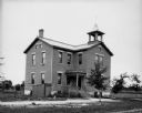
| Date: | 1909 |
|---|---|
| Description: | Exterior view of the Middleton High School. |

| Date: | 1904 |
|---|---|
| Description: | Back cover of an advertising catalog for International Harvester's Osborne line of harvesting machinery. The illustration shows a man with spectacles and g... |
If you didn't find the material you searched for, our Library Reference Staff can help.
Call our reference desk at 608-264-6535 or email us at: