Search: industry
Filter: Year of 1900-1999
Filter: Year of 1900-1909
Filter: Subject of lakes
Search: industry
Filter: Year of 1900-1999
Filter: Year of 1900-1909
Filter: Subject of lakes

| Date: | 1908 |
|---|---|
| Description: | A detail of a Sanborn map showing the area around North Franklin, North Blair and North Hancock Streets. |

| Date: | 1901 |
|---|---|
| Description: | Map shows townships, schools, creameries, post offices, and roads. The left side of the map features a legend with symbols for points of interest. |

| Date: | 1908 |
|---|---|
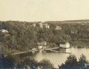
| Description: | View of the Knickerbocker Ice Company building. Rock Lake in the foreground. There is a ramp leading from the lake to the ice house. Caption reads: "The Ic... |

| Date: | 1909 |
|---|---|
| Description: | A map of Langlade County, Wisconsin that shows townships and ranges, towns, cities and villages, wagon roads, churches, schools, sawmills, town halls, chee... |
| Date: | 06 01 1900 |
|---|---|
| Description: | This map shows the the locations of different kinds of clay and shales throughout the state of Wisconsin. Includes a colored legend of types of clay and sh... |

| Date: | 1905 |
|---|---|
| Description: | Elevated view looking west over the Montello Granite Company's works framed by an irregular mask. Two wooden derricks and irregular blocks of granite are i... |
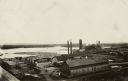
| Date: | 1900 |
|---|---|
| Description: | Elevated view of a lumber plant, with large stacks of lumber stacked around it. A lake is behind the plant. |

| Date: | 1900 |
|---|---|
| Description: | An architectural rendering of the Fauerbach Brewing Company. |
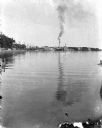
| Date: | 1905 |
|---|---|
| Description: | A view east along the north shore of Lake Monona, with Madison's east side industrial area in the background. The Deering Harvester Company is identified b... |

| Date: | 1903 |
|---|---|
| Description: | This map is ink on printed paper reading: "standard profile plate." "Surveyed Oct. 15, platted Dec. 15, 1903 ; surveyed May 9, platted Dec. 9." |

| Date: | 1900 |
|---|---|
| Description: | This map shows logging roads, railroads with spur lines, trails, rapids, lumber camps, Indian villages, summer resort, lakes, rivers, and ponds. |

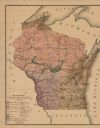
| Date: | 1906 |
|---|---|
| Description: | A commercial map of Wisconsin showing the location of creameries and cheese factories in the state. In the lower portion of the map provides the number of ... |

| Date: | 1908 |
|---|---|
| Description: | A view of the Montello granite quarry with Montello Lake in the background. The sign in the foreground reads, "J.T. Barrett Pays Highest Prices for Furs, M... |

| Date: | 1902 |
|---|---|
| Description: | This map shows townships, land parcels, schools, rivers, lakes, creameries, churches, cemeteries, roads, post offices, town halls, saw mills, roads and sto... |
| Date: | 1907 |
|---|---|
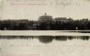
| Description: | Elevated view of the Che-ne-qua Hotel on Pine Lake. |
| Date: | 1905 |
|---|---|
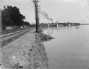
| Description: | A view east along the north shore of Lake Monona, with Madison's east side industrial area in the background. Tall utility poles and railroad tracks follow... |
| Date: | 1907 |
|---|---|
| Description: | Colorized view of Hotel Schwartz from across Elkhart Lake. Caption reads: "Hotel Schwartz, Elkhart Lake, Wis." |
| Date: | 06 1900 |
|---|---|
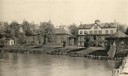
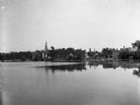
| Description: | View across Lake La Belle toward lakeside factories, residences, and churches. |
If you didn't find the material you searched for, our Library Reference Staff can help.
Call our reference desk at 608-264-6535 or email us at: