Search: industry
Filter: Year of 1900-1999
Filter: Year of 1900-1909
Filter: Subject of michigan, lake
Search: industry
Filter: Year of 1900-1999
Filter: Year of 1900-1909
Filter: Subject of michigan, lake
| Date: | 1900 |
|---|---|
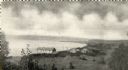
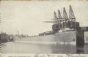
| Description: | Elevated view of east Green Bay harbor with cargo ships, W.W. Cagill Co., and other various industries. |
| Date: | 1900 |
|---|---|
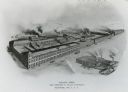
| Description: | Main factory with South Foundry in lower left. Lake Michigan is in the background. Later the Allis-Chalmers Manufacturing Co. |

| Date: | 1909 |
|---|---|
| Description: | [Lithography] by Poole Bros. Contains descriptive information. Short jaunts for busy people to nearby resorts in Illinois and Wisconsin. |
| Date: | 06 01 1900 |
|---|---|
| Description: | This map shows the the locations of different kinds of clay and shales throughout the state of Wisconsin. Includes a colored legend of types of clay and sh... |
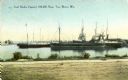
| Date: | 1900 |
|---|---|
| Description: | View from shoreline towards the coal docks on the right, with several ships in the harbor. Caption reads: "Coal Docks, Capacity 100,000 Tons, Two Rivers, W... |
| Date: | 1907 |
|---|---|
| Description: | View across Fish Creek Harbor to the village of Fish Creek and its pier, with warehouse. On the right is Dr. Weckler's Resort, a large wooden building with... |

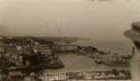
| Date: | 1907 |
|---|---|
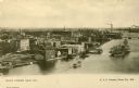
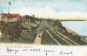
| Description: | Text on front: "Racine, Wis. Looking N.E." Elevated view of the city and harbor, looking Northeast. |

| Date: | 1906 |
|---|---|
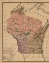
| Description: | A commercial map of Wisconsin showing the location of creameries and cheese factories in the state. In the lower portion of the map provides the number of ... |
| Date: | 1900 |
|---|---|
| Description: | Elevated view of the Pabst Whitefish Bay Resort. |
| Date: | 1909 |
|---|---|
| Description: | Elevated view of town. A person is in the right foreground. Caption reads: "A Glimpse(?) of Port Washington, Wis." |
| Date: | 10 17 1906 |
|---|---|
| Description: | Text on front reads: "Harbor View - Sheboygan, Wis." A lake freighter, or "laker" is docked at the harbor. |
| Date: | 1905 |
|---|---|
| Description: | Elevated view of people walking on a path by the Whitefish Bay Resort along the lake front. Caption reads: "Whitefish Bay Resort, Milwaukee." |

| Date: | 1900 |
|---|---|
| Description: | This map shows landownership, railroads, roads, churches, schools, cemeteries, post offices, townships, city wards, Lake Michigan, and rivers. The map incl... |
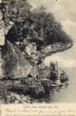
| Date: | 1906 |
|---|---|
| Description: | View of Lover's Leap with a group of people on the rocks near the shoreline under an overhang. Caption reads: "Lovers Leap, Sturgeon Bay, Wis." |
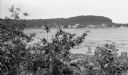
| Date: | 1902 |
|---|---|
| Description: | Elevated view of island with houses and boathouses and boats along the shoreline. Industrial buildings are in the background, and a sailboat is on the wate... |
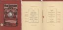
| Date: | 02 22 1902 |
|---|---|
| Description: | Front cover and menu page of the annual banquet of the Old Settlers' Club of Milwaukee County. On the cover is an oval tipped-in portrait of club president... |
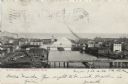
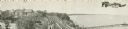
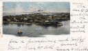
| Date: | 1905 |
|---|---|
| Description: | Elevated view over the Manitowoc River where it meets Lake Michigan. Downtown Manitowoc is on both sides, and people are on bridges crossing over the river... |
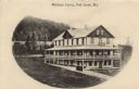
| Date: | 1907 |
|---|---|
| Description: | Slightly elevated view of a rectangular three-story building with wrap-around porches on the first and second floors. Tables and chairs are on the second f... |

| Date: | 1904 |
|---|---|
| Description: | A brochure for the lake region of north-eastern Illinois and south-eastern Wisconsin providing information on summer activities and places to stay in the a... |
If you didn't find the material you searched for, our Library Reference Staff can help.
Call our reference desk at 608-264-6535 or email us at: