Visit our other Wisconsin Historical Society websites!
 Search: industry
Filter: Year of 1900-1999
Filter: Year of 1900-1909
Filter: Subject of service industries
Search: industry
Filter: Year of 1900-1999
Filter: Year of 1900-1909
Filter: Subject of service industries

| Date: | 03 19 1909 |
|---|---|
| Description: | View of a furnace at McCormick Works. |

| Date: | 03 19 1909 |
|---|---|
| Description: | View of a furnace at McCormick Works. |

| Date: | 1900 |
|---|---|
| Description: | View from across street of a twine mill under construction. |
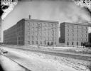
| Date: | 1900 |
|---|---|
| Description: | View from across street of a twine mill under construction. Snow is on the ground. |

| Date: | 1901 |
|---|---|
| Description: | Map shows lakes, rivers, schools, saw mills, post offices, creameries, and churches. Includes significant manuscript annotations showing township divisions... |
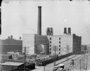
| Date: | 1900 |
|---|---|
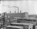
| Description: | Elevated view of McCormick Works, with construction of wheel shop. Streetcars are along the street in the foreground. |
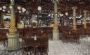
| Date: | 1905 |
|---|---|
| Description: | Hand-colored view of the interior of the bar room in the Schlitz Hotel. |
| Date: | 09 26 1906 |
|---|---|
| Description: | Menomonee Valley looking southeast from about N. 27th Street and W. St. Paul Avenue. A Milwaukee Gas Light Co. gas holder is on the left. |
| Date: | 04 29 1900 |
|---|---|
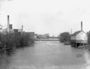
| Description: | View of the Globe Milling Company, built in 1848, and the Lewis Factory on the Rock River. In the distance is a dam, bridge, and barbershop. |

| Date: | 04 1901 |
|---|---|
| Description: | A Sanborn map of Watertown, including an index and a key. |

| Date: | 1900 |
|---|---|
| Description: | Shows lands belonging to Wisconsin Timber and Land Co., towns, post offices, saw mills, creameries, camps, churches, schools, farm houses, town halls, rail... |

| Date: | 1908 |
|---|---|
| Description: | A detail of a Sanborn map showing the area around North Franklin, North Blair and North Hancock Streets. |
| Date: | 1906 |
|---|---|
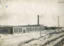
| Description: | Exterior view of the St. Paul Flax Twine MIll with a railroad track and power lines in the foreground. |
| Date: | 1902 |
|---|---|
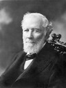
| Description: | William Deering (1826-1913), founder of the Deering Harvester Company. In 1902 the Deering company became part of the International Harvester Company. |
| Date: | 1900 |
|---|---|
| Description: | Elevated view of McCormick Works. In the foreground are powerlines, and beyond are railroad cars on railroad tracks. A large sign that reads (in reverse), ... |

| Date: | 1901 |
|---|---|
| Description: | Map shows townships, schools, creameries, post offices, and roads. The left side of the map features a legend with symbols for points of interest. |
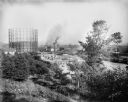
| Date: | 1905 |
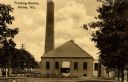
|---|---|
| Description: | Exterior view of a pumping station with a tall smokestack. Caption reads: "Pumping Station, Racine, Wis." |
If you didn't find the material you searched for, our Library Reference Staff can help.
Call our reference desk at 608-264-6535 or email us at:


