 Search: island
Filter: Year of 1800-1899
Search: island
Filter: Year of 1800-1899
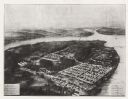
| Date: | 1864 |
|---|---|
| Description: | Aerial view, probably from a lithograph, of the prison for Confederate soldiers at Rock Island. |

| Date: | 1829 |
|---|---|
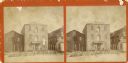
| Description: | Hand-colored lithograph of Fort Armstrong on Rock Island, based on a drawing by Henry Lewis. Foreground shows a tree floating in the water. |
| Date: | 1898 |
|---|---|
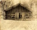
| Description: | A cabin (possibly of Bug-u-ma-ge-sik), located near the Ojibwa-Pillager Battle at Sugar Point on Bear Island. |
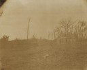
| Date: | 1898 |
|---|---|
| Description: | A forest from the Ojibwa-Pillager Battle at Sugar Point on Bear Island. |
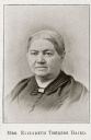
| Date: | 1889 |
|---|---|
| Description: | Portrait of Mrs. Elizabeth Thérèse Baird (1810-1889), an early resident of Mackinac Island. |
| Date: | 1890 |
|---|---|
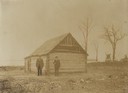
| Description: | Three men sitting in front of log building at Big Bay Beach on Madeline Island. |
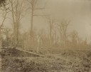
| Date: | 10 10 1898 |
|---|---|
| Description: | W.A. Jones and an unidentified man, probably on Bear Island, the location of the Ojibwa-Pillager Battle. |
| Date: | 10 10 1898 |
|---|---|
| Description: | W.A. Jones and an unidentified group, probably on Bear Island, the location of the Ojibwa-Pillager Battle. |
| Date: | 1898 |
|---|---|
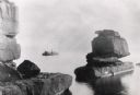
| Description: | Rock formation, The Sphinx, on Stockton Island of the Apostle Islands. Steamer "Edna" in background on Lake Superior. |
| Date: | 1870 |
|---|---|
| Description: | Stereograph of Island City Mill. Island City Mill was built in 1867 by Carl Stridde and A.H.F. Krueger, and also called Stridde & Krueger Mill. By 1891 it ... |

| Date: | 1856 |
|---|---|
| Description: | This map shows land ownership by name, a plat of Bayfield, local streets, part of Lake Superior, part of Madeline Island, and part of Bass Island. La Point... |

| Date: | 1850 |
|---|---|
| Description: | Pic Island on the north shore of Lake Superior. |
| Date: | 1892 |
|---|---|
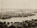
| Description: | Elevated view of fishing village on Jones Island, Milwaukee. Several fishing boats are docked along the shoreline. Large piles of lumber are in the foregro... |

| Date: | 1862 |
|---|---|
| Description: | This map of the Mississippi River between Island No. 8, northeast of New Madrid, Missouri, and Tiptonville, Tennessee, depicts the Confederate defenses at ... |

| Date: | 1857 |
|---|---|
| Description: | This map shows section corners, quarter section corners, foundry, steam saw mill, steam grist mill, planning mill, court house, baptist church, congregatio... |
| Date: | 1898 |
|---|---|
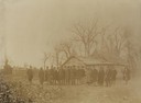
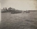
| Description: | Cavalry on a barge are going from or returning to Bear Island at the Ojibwa-Pillager Battle at Sugar Point on Bear Island. There are buildings along the fa... |

| Date: | 1852 |
|---|---|
| Description: | Illustration of four Indians on Madeline Island with a canoe in the water on the shore. |
| Date: | 1850 |
|---|---|
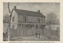
| Description: | Printed postcard of an illustration of the James Strang residence on Beaver Island, Michigan. Two men are standing in front of a stockade fence in front of... |
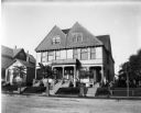
| Date: | 1898 |
|---|---|
| Description: | View across road of Syl standing in front of a three-story duplex house on Jones Island. |

| Date: | 1881 |
|---|---|
| Description: | This map is pen and ink on paper and shows part of the city of Menasha, local streets, Dendo Island, part of Lake Winnebago, and part of Little Lake Butte ... |
If you didn't find the material you searched for, our Library Reference Staff can help.
Call our reference desk at 608-264-6535 or email us at: