Search: islands
Filter: Subject of land
Filter: County of Door
Search: islands
Filter: Subject of land
Filter: County of Door

| Date: | 1959 |
|---|---|
| Description: | This map includes directories, illustrations, and an inset location map and also covers Rock, Hog, Detroit and Plum islands. |

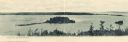
| Date: | 1954 |
|---|---|
| Description: | View looking west from Eagle Bluff toward Nicolet Bay, the Strawberry Islands, and Chambers Island. Three people are sitting on the stone wall of the overl... |

| Date: | 1930 |
|---|---|
| Description: | Aerial view over northern Door County, looking northeast across Europe Lake and Europe Bay toward Plum and Washington Islands. Farm fields and orchards con... |
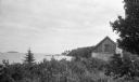
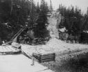
| Date: | 1926 |
|---|---|
| Description: | View of rustic cabin with a large stone chimney standing by the shore. There is another house or boathouse in the far background near the remains of a pier... |
| Date: | 1910 |
|---|---|
| Description: | View of Sawyer Harbor as seen from Government Bluff. |

| Date: | 1941 |
|---|---|
| Description: | This 1941 tourist map of Washington Island, Wisconsin, shows points of interest and places of business. Some information is shown pictorially. Rock, Hog, D... |
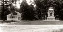
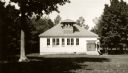
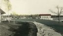
| Date: | 1929 |
|---|---|
| Description: | School and war memorial on Washington Island. |
| Date: | |
|---|---|
| Description: | The stairs and dock at the lighthouse on Rock Island. |
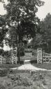
| Date: | |
|---|---|
| Description: | The entrance to the garden framed by a decorative wooden gate. |

| Date: | 1899 |
|---|---|
| Description: | Map of Door County with inset photograph of Sturgeon Bay City. |

| Date: | 1920 |
|---|---|
| Description: | View from beach across Spike Horn Bay towards Cana Island and the Cana Island Light. |

| Date: | 1930 |
|---|---|
| Description: | Aerial view looking northeast, with Rowley's Bay in the foreground. Europe Lake is to the left, with Europe Bay and Newport Bay separated by a narrow peni... |

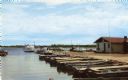
| Date: | 1929 |
|---|---|
| Description: | Ferryboat landing, with the boats providing service between Gills Rock and Washington Island. |
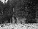
| Date: | 08 23 1964 |
|---|---|
| Description: | A large rock outcropping covered with trees and plants on a rocky beach of Lake Michigan. |
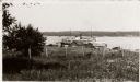
| Date: | 1925 |
|---|---|
| Description: | Washington Island, including field and fence, with buildings, automobiles, and a large ship in the distance. |
| Date: | |
|---|---|
| Description: | Hand-colored view of the Thordarson estate including the boathouse and a stone-paved path with benches. |

| Date: | 08 24 1964 |
|---|---|
| Description: | View of a forest interior as seen from West Harbor Road. A large variety of vegetation grows within the forest. |
If you didn't find the material you searched for, our Library Reference Staff can help.
Call our reference desk at 608-264-6535 or email us at: