 Search: islands
Filter: Subject of land
Filter: Subject of islands
Search: islands
Filter: Subject of land
Filter: Subject of islands

| Date: | |
|---|---|
| Description: | A family kayaks in front of rock walls at the Apostle Islands. |

| Date: | 02 26 1887 |
|---|---|
| Description: | Bird's-eye map of Ashland, and the Apostle Islands in Lake Superior. Caption reads: "Ashland and the Apostle Islands." |
| Date: | 1950 |
|---|---|
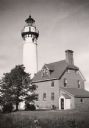
| Description: | Lighthouse on Outer Island of the Apostle Islands. |

| Date: | |
|---|---|
| Description: | Elevated view of a landscape in the Pacific islands, probably Hawaii. |

| Date: | 1884 |
|---|---|
| Description: | Panorama bird's-eye view of the town of Ashland, on Lake Superior, and the Apostle Islands. |

| Date: | 1967 |
|---|---|
| Description: | Nelson sits in a canoe and looks out over the water around the Apostle Islands. |
| Date: | |
|---|---|
| Description: | La Pointe Light on Long Island (Apostle Islands), Chequamegon Bay, Lake Superior. |

| Date: | 1878 |
|---|---|
| Description: | A color map detailing Ashland and Bayfield counties, including Lake Superior and the Apostle Islands. |
| Date: | |
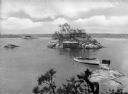
|---|---|
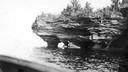
| Description: | Devils Island on Lake Superior, outermost of the Apostle Islands group. There appears to be the edge of a boat in the foreground. |
| Date: | |
|---|---|
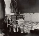
| Description: | A bedroom on one of the South Carolina islands which hosted the Citizenship group. |

| Date: | 1880 |
|---|---|
| Description: | This copy of an 1834 map in the American Fur Company's papers held by the New-York Historical Society shows an outline of Chequamegon Bay and Madeline Isla... |

| Date: | 1907 |
|---|---|
| Description: | Hand-colored view across water towards three islands in big Cedar Lake. The center island has a resort building with a red roof. |
| Date: | 1913 |
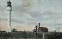
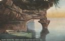
|---|---|
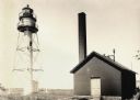
| Description: | Hand-colored postcard showing the lighthouse and fog signal at Devil's Island in the Apostle Islands. Caption reads: "Apostle Islands, Wis. Devil's Island,... |
| Date: | |
|---|---|
| Description: | Elevated view from Hubinger's Island featuring other islands, homes, and a boat. |

| Date: | 1981 |
|---|---|
| Description: | Plat map of Madeline Island surrounded by Basswood, Michigan and Gull Islands. |
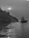
| Date: | 1940 |
|---|---|
| Description: | The moon, partially obstructed by clouds, is reflected in the waters off one of the Apostle Islands. There is a small islet on the right, with several tree... |

| Date: | |
|---|---|
| Description: | Elevated city view showing the sea and islands. A bridge spans the shoreline. Published by Owl Drug Co. |

| Date: | 1886 |
|---|---|
| Description: | Bird's-eye view of Bayfield, county seat of Bayfield County. On the lower left side is an inset for Bayfield and the Apostle Islands. |
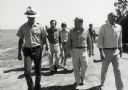
| Date: | 1979 |
|---|---|
| Description: | Senator Gaylord Nelson, Dave Obey, and Secretary of the Interior Cecil Andrus, walk along a beach with a park ranger during a tour of the Apostle Islands. ... |
| Date: | |
|---|---|
| Description: | Postcard of the "Vessel's Stern and Rudder Post" geological formation on Madeline Island, one of the Apostle Islands. View of the shoreline and a man sitti... |
If you didn't find the material you searched for, our Library Reference Staff can help.
Call our reference desk at 608-264-6535 or email us at: