 Search: islands
Filter: Subject of land
Search: islands
Filter: Subject of land
| Date: | 1934 |
|---|---|
| Description: | View from water of Devil's Island lighthouse located above sandstone caves and arches in the Apostle Islands of Lake Superior. Caption reads: "Devil's Isla... |

| Date: | 1884 |
|---|---|
| Description: | A detailed, hand-colored map of Wisconsin and the western portion of Michigan’s Upper Peninsula, which also includes an inset of Isle Royale in Lake Superi... |

| Date: | 1908 |
|---|---|
| Description: | A detailed map of Michigan Island and Gull Island in the Apostle Islands group (T51N, R1W, 4 M) that shows sections, landowners, the Michigan Island Lighth... |

| Date: | 1871 |
|---|---|
| Description: | Asaph Whittlesey arrived in Ashland in 1854, one of the earliest of the settlers who hoped the area would grow and make their fortunes. He drew this map of... |

| Date: | 1871 |
|---|---|
| Description: | Asaph Whittlesey arrived in Ashland in 1854, one of the earliest of the settlers who hoped the area would grow and make their fortunes. He drew this map of... |

| Date: | 1893 |
|---|---|
| Description: | This map of La Crosse shows wards 1-20, streets, railroads, the Inter State Fair Grounds, islands, and the Mississippi River. Relief is shown by hachures. ... |

| Date: | 1893 |
|---|---|
| Description: | This map shows the depths of the East Neebish Rapids and the different types of minerals that make up the floor bed. Islands and Canada West is labeled. No... |

| Date: | 1700 |
|---|---|
| Description: | Map of the western hemisphere showing settelments, coastal features, islands, rivers, lakes, and pictoral representations of forests and mountains. The Gre... |

| Date: | 1709 |
|---|---|
| Description: | Map of North America, showing a few of the largest settlements, regions, islands, and a few rivers. The Great Lakes are depicted, but over-sized, and Calif... |
| Date: | 1907 |
|---|---|
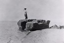
| Description: | Woman standing on soldier's rock on Madeline Island. |

| Date: | 1899 |
|---|---|
| Description: | A young Aldo Leopold posing proudly with his bamboo fishing pole, stringer of perch and a dog. The family was on vacation in the Cheneaux Islands, near Mac... |

| Date: | 1769 |
|---|---|
| Description: | Double hemispherical map showing the continents, islands, countries, and a few major cities of the world. The routes of a few explorers are depicted and la... |

| Date: | |
|---|---|
| Description: | Seven teenage girls posing on a dock on on one of the Apostle Islands. |

| Date: | 1891 |
|---|---|
| Description: | This map of La Crosse shows eighteen city wards in red, railroads, cemeteries, fair grounds, labeled streets, islands, and the Mississippi River. The left ... |

| Date: | |
|---|---|
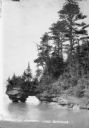
| Description: | View from shoreline of a lake. Trees and plants are in the foreground, and across the water may be islands as well as the far shoreline, which are tree-cov... |

| Date: | 1795 |
|---|---|
| Description: | Map of Massachusetts showing counties, cities, roads, islands (including Nantucket and Martha's Vineyard), mountains, hills, lakes, and rivers. Two small e... |
| Date: | 1913 |
|---|---|
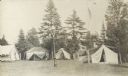
| Description: | Camp Stella on Sand Island of the Apostle Islands. View includes tents, lamp post, bridge and flag pole. |
| Date: | 1934 |
|---|---|
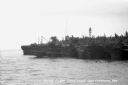
| Description: | View across water of sandstone cliff shoreline along Lake Superior at the Apostle Islands. On the far right a boat is pulled up onshore, and painted on the... |

| Date: | 1856 |
|---|---|
| Description: | A hand-colored map of Wisconsin, showing the county boundaries, towns, cities, railroads, roads, lakes, rivers, bays, and the Lake Superior’s islands. In ... |

| Date: | 1930 |
|---|---|
| Description: | Aerial view over northern Door County, looking northeast across Europe Lake and Europe Bay toward Plum and Washington Islands. Farm fields and orchards con... |
If you didn't find the material you searched for, our Library Reference Staff can help.
Call our reference desk at 608-264-6535 or email us at: