Search: islands
Filter: Subject of land
Search: islands
Filter: Subject of land
| Date: | 1916 |
|---|---|
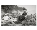
| Description: | Picnic on the shores of Basswood Island, Apostle Islands. Those picnicking include Harriet Webb, C.A. Hull, H.W. Rodgers, Mrs. J. Austin, Elizabeth Baker, ... |
| Date: | 1902 |
|---|---|
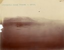
| Description: | A distant view of Pyramid Lake's Rattlesnake Island. |
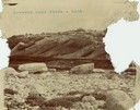
| Date: | 1902 |
|---|---|
| Description: | A rock formation on Pyramid Lake's Rattlesnake Island. |
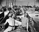
| Date: | 1944 |
|---|---|
| Description: | Soldiers, supplies and an International TD-9 diesel crawler tractor (TracTracTor) on a beach at Eniwetok Atoll in the Marshall Islands during World War II.... |

| Date: | 1916 |
|---|---|
| Description: | Group of people gathered for a rustic picnic on Bear Island, Apostle Islands, Lake Superior. Image includes Mrs. J.L. Abernathy, Cora A. Hull, Mrs F.B. Chu... |

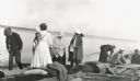
| Date: | 1916 |
|---|---|
| Description: | Group having a picnic on Bear Island of the Apostle Islands. Group includes Cora A. Hull, Mrs. Chute, John Webb, Bob Webb, Mrs. Webb, Mrs. Austin, and Mr. ... |
| Date: | 08 22 1916 |
|---|---|
| Description: | Group setting up for a picnic at the shoreline on Bear Island of the Apostle Islands. Image includes A.G. Hull, Elizabeth Nisbet (Mrs. S.C. Marty Sr.), Eli... |
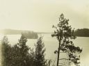
| Date: | 1910 |
|---|---|
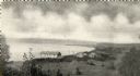
| Description: | Elevated view from hill through tall trees of Basswood Lake. |

| Date: | 1795 |
|---|---|
| Description: | Map of Connecticut showing counties, townships, cities, roads, islands, swamps, hills, mountains, lakes, rivers, reefs, and numerous other geographical and... |
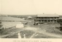
| Date: | |
|---|---|
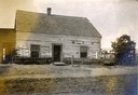
| Description: | The Old Mission, including the Old Mission Inn on Madeline Island. |

| Date: | 1627 |
|---|---|
| Description: | Map of North and South America showing settlements, rivers, lakes, mountains, islands and regions of the western hemisphere. It includes an inset map of Gr... |

| Date: | 1761 |
|---|---|
| Description: | Map covering southern Louisiana from Lake Ponchetrain to the Golf of Mexico and from Woods Bay in the west to the islands just east of Bay St. Louis. It sh... |
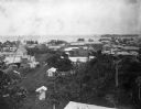
| Date: | 1902 |
|---|---|
| Description: | Elevated view of the city of Port Limon, Costa Rica with the Caribbean Sea in the background. Trees grow amongst the many commercial and residential buildi... |

| Date: | 09 04 1913 |
|---|---|
| Description: | Text on front reads: "'Castle Rock,' 2nd Peak, Trempealeau, Wis., on-the-Mississippi." Elevated view towards a rock formation on the Mississippi River. Isl... |

| Date: | 1853 |
|---|---|
| Description: | A map of Wellfleet Harbor on Cape Cod Bay. |
If you didn't find the material you searched for, our Library Reference Staff can help.
Call our reference desk at 608-264-6535 or email us at: