 Search: islands
Filter: Subject of land
Search: islands
Filter: Subject of land
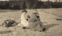
| Date: | 1920 |
|---|---|
| Description: | Mrs. Cora Hull & Mrs. Julia Wood are seated on the sandy shore of one of the Apostle Islands overlooking Lake Superior. |

| Date: | 07 01 1954 |
|---|---|
| Description: | Sigurd Olson, followed by Tony Lovink, at the beginning of their "grand portage." A large lake and islands are in the background. |
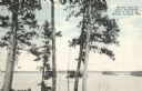
| Date: | |
|---|---|
| Description: | Colorized postcard of Boulder Lake. Pine trees are in the foreground and islands are below in the background. Caption reads: "Boulder Lake at Camp Manitowi... |

| Date: | 1909 |
|---|---|
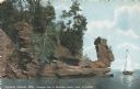
| Description: | Postcard of the overhanging cliffs near the stone quarry on Presque Isle or Stockton Island's. Caption reads: "Apostle Islands, Wis. Presque Isle or Stockt... |

| Date: | 1979 |
|---|---|
| Description: | David and Joan Obey (right) with Senator Gaylord Nelson (2nd from left) and Secretary of the Interior Cecil Andrus (on Nelson's left) on an Apostle Islands... |

| Date: | 1940 |
|---|---|
| Description: | Text on front reads: "Billings Park, Superior, Wis." A city park on the St. Louis River, a freshwater estuary. Small islands with several bridges are surro... |
| Date: | 1912 |
|---|---|
| Description: | Picnic party on the rocks along the shore, among the Apostle Islands in Lake Superior. |

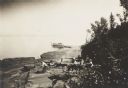
| Date: | 1942 |
|---|---|
| Description: | This photocopy plat map represents the relative position and size of the sloughs and islands in the Mississippi River, opposite Prairie du Chien. |
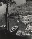
| Date: | 1956 |
|---|---|
| Description: | Elevated view of a rowboat moored in a small cove on Madeline Island in the Apostle Islands. |
| Date: | 1967 |
|---|---|
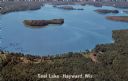
| Description: | Aerial view of a lake with islands surrounded by forest. Text on reverse reads: "Joined by a navigable water channel to Lost Land Lake this combined wat... |

| Date: | 1935 |
|---|---|
| Description: | A frenzy of gulls feeding on a pile of fish on one of the Apostle Islands, Lake Superior. |
| Date: | |
|---|---|
| Description: | Postcard of the "Indian Head," or profile, a geological rock formation on the shorelinr. Caption reads: "Apostle Islands, Wis. Presque Isle or Stockton, In... |

| Date: | |
|---|---|
| Description: | A map of La Crosse, Wisconsin and La Crescent, Minnesota, showing sectional divisions along the shore and islands of the Mississippi River. The areas also ... |

| Date: | 1834 |
|---|---|
| Description: | This copy of an 1834 map in the American Fur Company's papers held by the New-York Historical Society shows an outline of Chequamegon Bay and Madeline Isla... |

| Date: | 1963 |
|---|---|
| Description: | Gaylord Nelson, John F. Kennedy, and John Reynolds on the 1963 tour of the Apostle Islands. There is a U.S. Army helicopter in the background. |

| Date: | 1888 |
|---|---|
| Description: | This map shows counties, lakes, railroads, and rivers. Lake Michigan, Lake Superior, and the Apostle Islands are labeled. A table of railroad lines with mi... |

| Date: | 1934 |
|---|---|
| Description: | Aerial view of Long Lake and its islands. A road leads out to the biggest island. Caption reads: "Woodland Park, Long Lake, Haugen, Wis. Aerial Photo by N.... |
| Date: | |
|---|---|
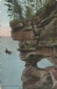
| Description: | Colorized postcard of a port hole through the north cape or point of Presque Isle or Stockton Island, part of the Apostle Islands. A person in a boat is ou... |

| Date: | 1907 |
|---|---|
| Description: | A map of the eastern portion of the Apostle Islands group, and a detailed map of Gull Island showing the relief on the island, are included here, along wit... |

| Date: | 1900 |
|---|---|
| Description: | This chart of the northern Apostle Islands and Lake Superior shoreline shows relief by contours and spot heights and depths by contours, gradient tints and... |
If you didn't find the material you searched for, our Library Reference Staff can help.
Call our reference desk at 608-264-6535 or email us at: