 Search: islands
Filter: Subject of superior, lake
Search: islands
Filter: Subject of superior, lake

| Date: | |
|---|---|
| Description: | A family kayaks in front of rock walls at the Apostle Islands. |

| Date: | 02 26 1887 |
|---|---|
| Description: | Bird's-eye map of Ashland, and the Apostle Islands in Lake Superior. Caption reads: "Ashland and the Apostle Islands." |
| Date: | 1950 |
|---|---|
| Description: | Lighthouse on Outer Island of the Apostle Islands. |

| Date: | |
|---|---|
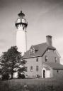
| Description: | Michigan Island Lighthouse, Apostle Islands, Lake Superior. |
| Date: | |
|---|---|
| Description: | Colorized postcard of Rembrandt Arch, a geological formation on the Apostle Islands. Caption reads: "Rembrandt Arch, Apostle Islands, Lake Superior." |

| Date: | 1884 |
|---|---|
| Description: | Panorama bird's-eye view of the town of Ashland, on Lake Superior, and the Apostle Islands. |
| Date: | |
|---|---|
| Description: | La Pointe Light on Long Island (Apostle Islands), Chequamegon Bay, Lake Superior. |

| Date: | 1878 |
|---|---|
| Description: | A color map detailing Ashland and Bayfield counties, including Lake Superior and the Apostle Islands. |
| Date: | |
|---|---|
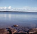
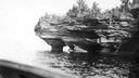
| Description: | View from rocky shoreline of towards one of the Apostle Islands across the water. |

| Date: | |
|---|---|
| Description: | A map of the Apostle Islands, including the harbor of Bayfield and its surroundings. |
| Date: | |
|---|---|
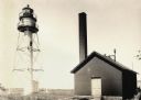
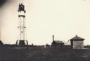
| Description: | Lighthouse and buildings on Devil's Island of the Apostle Islands. |
| Date: | |
|---|---|
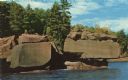
| Description: | Photographic postcard of the rock formations on the shore of Stockton Island, one of the twenty-one islands comprising the Apostle Islands in Lake Superio... |

| Date: | |
|---|---|
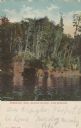
| Description: | Color postcard of a sandy shoreline on one of the Apostle Islands. Caption reads: "Apostle Island Scene." |
| Date: | |
|---|---|
| Description: | Devils Island on Lake Superior, outermost of the Apostle Islands group. There appears to be the edge of a boat in the foreground. |
| Date: | |
|---|---|
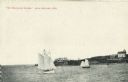
| Description: | View across water towards two schooners off the shore of Madeline Island, one of the islands that comprise the Apostle Islands in Lake Superior. Two large ... |

| Date: | 1880 |
|---|---|
| Description: | This copy of an 1834 map in the American Fur Company's papers held by the New-York Historical Society shows an outline of Chequamegon Bay and Madeline Isla... |
| Date: | |
|---|---|
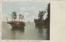
| Description: | Colorized postcard of the Profile Rock geological formation among the Apostle Islands on Lake Superior. A sailboat is in the far background Caption reads: ... |

| Date: | 1981 |
|---|---|
| Description: | Plat map of Madeline Island surrounded by Basswood, Michigan and Gull Islands. |
| Date: | 1940 |
|---|---|
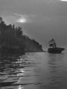
| Description: | The moon, partially obstructed by clouds, is reflected in the waters off one of the Apostle Islands. There is a small islet on the right, with several tree... |

| Date: | 1886 |
|---|---|
| Description: | Bird's-eye view of Bayfield, county seat of Bayfield County. On the lower left side is an inset for Bayfield and the Apostle Islands. |
If you didn't find the material you searched for, our Library Reference Staff can help.
Call our reference desk at 608-264-6535 or email us at: