Search: lake
Filter: Categories of Wisconsin Historical Images
Search: lake
Filter: Categories of Wisconsin Historical Images

| Date: | 1935 |
|---|---|
| Description: | This map shows railroads, telephone lines, roads, trails, schools, sub-agency, lookout stations, churches, community centers, and school site and farm. Bil... |

| Date: | 1848 |
|---|---|
| Description: | This map shows lighthouses on part of Lake Superior, Green Bay, Lake Michigan, Lake Huron, Lake St. Clair, Lake Erie, Lake Ontario, the St. Lawrence River,... |
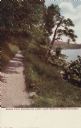
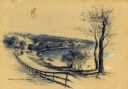
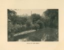
| Date: | |
|---|---|
| Description: | View along shore path at Lake Geneva. Caption reads: "Shore Path Encircling Lake — Lake Geneva (Near Chicago)." |

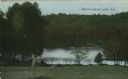
| Date: | 07 24 1911 |
|---|---|
| Description: | Text on front reads: "Rock Lake, Lake Mills, Wis." A sailboat on the lake at sunset. Rock Lake is a 1365 acre lake with a maximum depth of 60 feet on the W... |
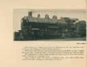
| Date: | 1915 |
|---|---|
| Description: | The Lake Geneva Express train, engine number 1526, which ran between Lake Geneva and Chicago. |

| Date: | 1905 |
|---|---|
| Description: | View of Shell Lake. There are railroad tracks i the foreground. Caption reads: "Shell Lake Wis." |
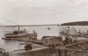
| Date: | 1895 |
|---|---|
| Description: | Elevated view of Lake Geneva with the Lake Geneva steamboat. |
| Date: | 1915 |
|---|---|
| Description: | The north shore of the Lake Geneva outlet. |
| Date: | 1910 |
|---|---|
| Description: | Colorized postcard view down hill toward the lake. Caption reads: "South Clear Lake, Wis." |
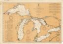
| Date: | 08 30 1911 |
|---|---|
| Description: | Chart showing all of the Great Lakes: Lake Superior, Lake Michigan, Lake Huron, Lake Erie, and Lake Ontario and canals, rivers and cities that border the l... |

| Date: | 1928 |
|---|---|
| Description: | Birds-eye view showing Lake Mendota, Lake Monona, Lake Wingra, Lake Waubesa and Lake Kegonsa. Shows the growth of Madison from the Isthmus along the southe... |
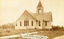
| Date: | 1905 |
|---|---|
| Description: | The Methodist Episcopal Church in Balsam Lake. Caption reads: 1ST M. E. Church — Balsam Lake WIS". |
If you didn't find the material you searched for, our Library Reference Staff can help.
Call our reference desk at 608-264-6535 or email us at: