Search: lapham

| Date: | 1855 |
|---|---|
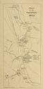
| Description: | This map by Increase Lapham shows the Penokee Iron Range in Ashland and Iron counties, Wisconsin. Part of the Gogebic Range, the Penokees extend from an ar... |

| Date: | 11 1953 |
|---|---|
| Description: | Lapham School third grade children observing milking machinery during a tour of the Bowman Farm Dairy on Fish Hatchery Road. Identified left to right are C... |

| Date: | 11 1953 |
|---|---|
| Description: | Four Lapham School students and an adult eating ice cream from a paper cup at the end of a tour of Bowman Farm Dairy on Fish Hatchery Road. |

| Community: | West Allis |
|---|---|
| County: | Milwaukee |
| Historic Name: | |
| Reference Number: | 144814 |
| Date: | 1845 |
|---|---|
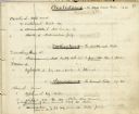
| Description: | Page from Increase Lapham's 1845 list of plants of Wisconsin including Oxalidaceae, Zanthoxylaceae, and Anacardiaceae and notations of where and when indiv... |

| Date: | 1833 |
|---|---|
| Description: | Increase Lapham's plan for the canal terminus on Portsmouth Point at the confluence of the Scioto and Ohio Rivers. |

| Community: | West Allis |
|---|---|
| County: | Milwaukee |
| Historic Name: | |
| Reference Number: | 144812 |

| Date: | 10 31 1950 |
|---|---|
| Description: | At Lapham School, more than 800 costumed children and their parents attended one of the largest Halloween night parties held in Madison. A boy is shown bob... |

| Date: | 1866 |
|---|---|
| Description: | This manuscript map by Increase Lapham shows the Dells of the Wisconsin River, from Stand Rock and Witches Gulch at the north to a point approximately one ... |

| Date: | 10 29 1930 |
|---|---|
| Description: | Six kindergarten children wearing aprons stand in front of a classroom grocery display at Lapham School, 1436 E. Dayton Street. |

| Date: | 1907 |
|---|---|
| Description: | The Yahara River Parkway, with the old Lapham School at 1436 East Dayton Street at North Thornton visible on the righthand side. |

| Date: | |
|---|---|
| Description: | Letterhead stationery featuring an engraving of the Milwaukee Iron Company foundry. The letter is from an officer of the company to noted geologist Increas... |

| Date: | 1828 |
|---|---|
| Description: | Increase Lapham's drawing and description of an earth borer for his handwritten manuscript, Notes and Accounts of Canals, Particularly the Ohio Canal Ne... |
| Date: | 11 08 1960 |
|---|---|
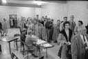
| Description: | A crowd of Second Ward voters in Lapham School, 1045 E. Dayton Street. |

| Community: | Oconomowoc |
|---|---|
| County: | Waukesha |
| Historic Name: | |
| Reference Number: | 8519 |
| Date: | 1874 |
|---|---|
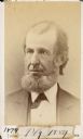
| Description: | Carte-de-visite portrait of Dr. Philo R. Hoy (1816-1892), Wisconsin ornithologist and entomologist. Settled in Racine with his family in 1846. Served as pr... |

| Date: | 1848 |
|---|---|
| Description: | This map by Increase Lapham shows the township and range system in southern and eastern Wisconsin as well as along the Wisconsin River in present-day Marat... |

| Community: | Milwaukee |
|---|---|
| County: | Milwaukee |
| Historic Name: | Allen-Field School |
| Reference Number: | 237876 |
If you didn't find the material you searched for, our Library Reference Staff can help.
Call our reference desk at 608-264-6535 or email us at: