Search: lead
Search: mines
Search: mining
Filter: Categories of Wisconsin Historical Images
Filter: Subject of land
Search: lead
Search: mines
Search: mining
Filter: Categories of Wisconsin Historical Images
Filter: Subject of land
| Date: | 1850 |
|---|---|
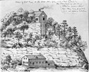
| Description: | Blast furnace, also known as a Scotch hearth used in lead mining. |

| Date: | 1936 |
|---|---|
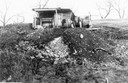
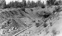
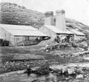
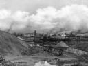
| Description: | View from road of lead and zinc mines and surrounding buildings. |
| Date: | 1853 |
|---|---|
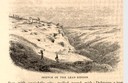
| Description: | Engraved view of miners and hillside mines in the Lead Region. Caption reads: "Sketch of the Lead Region." |

| Date: | 1829 |
|---|---|
| Description: | Photoprint of Crawford County lead district map. |

| Date: | 1829 |
|---|---|
| Description: | Cincinnati, Ohio, Ebr. Martin, engraver. |
| Date: | |
|---|---|
| Description: | Webb City was known as the world's largest and most productive lead and zinc mining field in the late 1800s and early 1900s and was part of the "Tri-State ... |

| Date: | 1920 |
|---|---|
| Description: | An ink on tracing paper, hand-drawn map that shows lead mines, the boundary of the lead bearing strata, and the military road in Lafayette, Grant, Iowa, an... |

| Date: | 1800 |
|---|---|
| Description: | Map of the United States. It shows the states, including Tennessee, cities, towns, Native American land, mountains, lakes, and rivers. Lead mines appear ju... |

| Date: | |
|---|---|
| Description: | Soon after the turn of the century, Joplin was named the lead and zinc capital of the world. |
| Date: | |
|---|---|
| Description: | Soon after the turn of the century, Joplin was named the lead and zinc capital of the world. |
| Date: | |
|---|---|
| Description: | The Mammoth and Standard Mining Mills has been producing silver, gold, lead, zinc and copper continuously since 1884. Caption reads: "Mammouth and Standard... |

| Date: | 1960 |
|---|---|
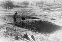
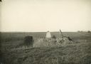
| Description: | A man is running his dog on a trail in an old lead mining area. The trees are bare and fallen leaves are covering the ground. |

| Date: | 1888 |
|---|---|
| Description: | This is a reproduction of a map originally published in 1829 by R.W. Chandler, a pioneer settler of Galena. It is based on an earlier map by surveyor Luciu... |
| Date: | |
|---|---|
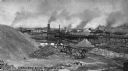
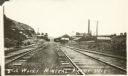
| Description: | View down railroad tracks that lead to industrial buildings and a smokestack. A caption on the image reads, "Zink (Zinc) Works, Mineral Point, Wis." |

| Date: | 1805 |
|---|---|
| Description: | Map of the United States. It shows the states, cities, towns, Native American land, mountains, lakes, and rivers. Tennessee, Kentucky, and Ohio are labeled... |
If you didn't find the material you searched for, our Library Reference Staff can help.
Call our reference desk at 608-264-6535 or email us at: