Search: lead
Search: mines
Search: mining
Filter: Categories of Wisconsin Historical Images
Filter: Subject of lead mines and mining
Search: lead
Search: mines
Search: mining
Filter: Categories of Wisconsin Historical Images
Filter: Subject of lead mines and mining

| Date: | 1920 |
|---|---|
| Description: | An ink on tracing paper, hand-drawn map that shows lead mines, the boundary of the lead bearing strata, and the military road in Lafayette, Grant, Iowa, an... |

| Date: | 1800 |
|---|---|
| Description: | Map of the United States. It shows the states, including Tennessee, cities, towns, Native American land, mountains, lakes, and rivers. Lead mines appear ju... |
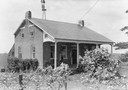
| Date: | |
|---|---|
| Description: | Uppena home, built by Bernard Henry Uppena in 1850. |
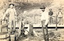
| Date: | |
|---|---|
| Description: | Early Wisconsin lead miners using a Pioneer Windlass. |

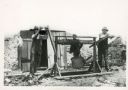
| Date: | 1939 |
|---|---|
| Description: | International PA-100 power unit operating a Pomona water pump in a lead and zinc mine. A box labeled "dynamite" is in the foreground. |
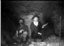
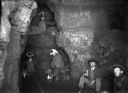
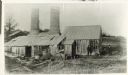
| Date: | 1900 |
|---|---|
| Description: | Interior of a lead mine showing two miners kneeling with candles in their hands. |
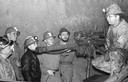
| Date: | 1950 |
|---|---|
| Description: | Students from Platteville, Wisconsin tour a mine to see how lead is extracted. |
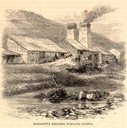
| Date: | 05 1866 |
|---|---|
| Description: | Engraved exterior view of a smelting furnace with a small group of men with horses gathered in front. |
| Date: | |
|---|---|
| Description: | Miners probably grading galena (lead) ore by putting pieces in drums with holes and letting smaller ones fall through. |

| Date: | 1960 |
|---|---|
| Description: | A man is running his dog on a trail in an old lead mining area. The trees are bare and fallen leaves are covering the ground. |

| Date: | 1888 |
|---|---|
| Description: | This is a reproduction of a map originally published in 1829 by R.W. Chandler, a pioneer settler of Galena. It is based on an earlier map by surveyor Luciu... |
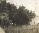
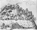
| Date: | 1900 |
|---|---|
| Description: | View of the Gratiot homestead at Gratiot's Grove Site. |
| Date: | 1872 |
|---|---|
| Description: | Galena (lead sulfide) was melted at this open hearth furnace owned by Richard Straw and Company on the Roundtree Branch of the Little Platte River. The men... |
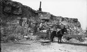
| Date: | |
|---|---|
| Description: | Miners and a mule work outside an iron mine near Mayville. |
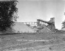
| Date: | |
|---|---|
| Description: | Exterior view of James Mine with a field and fence in the foreground. Tram tracks lead from the tall building to large piles of rocks. There are steep stai... |

| Date: | 1805 |
|---|---|
| Description: | Map of the United States. It shows the states, cities, towns, Native American land, mountains, lakes, and rivers. Tennessee, Kentucky, and Ohio are labeled... |
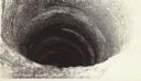
| Date: | |
|---|---|
| Description: | The 120 foot shot shaft below the shot tower at Tower Hill State Park. |
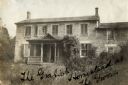
| Date: | 1900 |
|---|---|
| Description: | Exterior view of the Gratiot homestead at Gratiot's Grove Site. Handwriting on front reads: "The Gratiot Homestead at the (?)on." |
If you didn't find the material you searched for, our Library Reference Staff can help.
Call our reference desk at 608-264-6535 or email us at: