 Search: lead
Search: mines
Search: mining
Filter: Categories of Wisconsin Historical Images
Filter: Subject of lead mines and mining
Search: lead
Search: mines
Search: mining
Filter: Categories of Wisconsin Historical Images
Filter: Subject of lead mines and mining

| Date: | 1866 |
|---|---|
| Description: | This map shows the location of county boundaries, cities, rivers, lakes, grant railroads, wagon roads, land office locations, iron, copper and lead deposit... |
| Date: | |
|---|---|
| Description: | John L. Lewis, in miner's hat, after West Frankfort, Illinois, mine disaster. |

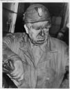
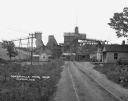
| Date: | 1948 |
|---|---|
| Description: | Large brick kiln-like structure in field. Built in 1876, the blast furnace was used to salvage additional lead from the slag of 18 area furnaces operating ... |
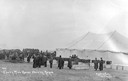
| Date: | 11 1909 |
|---|---|
| Description: | Photographic postcard of funeral and tent/morgue from the Cherry Mine disaster. Caption reads: "#37 Cherry Mine Horror Showing Morgue Dunham Photo Princeto... |

| Date: | 1867 |
|---|---|
| Description: | This 1867 manuscript map by Increase Lapham shows the topography and geology of the Blue Mounds region in the Town of Brigham in Iowa County and the towns ... |
| Date: | 1925 |
|---|---|
| Description: | View down road leading up to the Cokerville Mine. Two horses pulling a wagon are near the road, and automobiles are parked on the right near a building wit... |
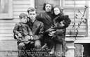
| Date: | 11 1909 |
|---|---|
| Description: | Group portrait of a family. Caption reads: "W.H. Clelland and Family. One of the Cherry Mine survivers [sic]. It is this man who was said to have le... |
If you didn't find the material you searched for, our Library Reference Staff can help.
Call our reference desk at 608-264-6535 or email us at: