Search: lead
Search: mines
Search: mining
Filter: Categories of Wisconsin Historical Images
Filter: Subject of mines and mineral resources
Search: lead
Search: mines
Search: mining
Filter: Categories of Wisconsin Historical Images
Filter: Subject of mines and mineral resources

| Date: | 1936 |
|---|---|
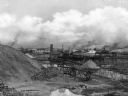
| Description: | View from road of lead and zinc mines and surrounding buildings. |
| Date: | |
|---|---|
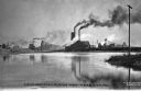
| Description: | Webb City was known as the world's largest and most productive lead and zinc mining field in the late 1800s and early 1900s and was part of the "Tri-State ... |
| Date: | |
|---|---|
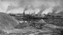
| Description: | Webb City was known as the world's largest and most productive lead and zinc mining field in the late 1800s and early 1900s and was part of the "Tri-State ... |

| Date: | 1800 |
|---|---|
| Description: | Map of the United States. It shows the states, including Tennessee, cities, towns, Native American land, mountains, lakes, and rivers. Lead mines appear ju... |
| Date: | |
|---|---|
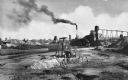
| Description: | Webb City was known as the world's largest and most productive lead and zinc mining field in the late 1800s and early 1900s and was part of the "Tri-State ... |
| Date: | |
|---|---|
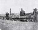
| Description: | An unidentified mining scene where two men are cranking a windlass, common only in early lead and zinc mining in southwest Wisconsin. The windlass was used... |

| Date: | 1939 |
|---|---|
| Description: | International PA-100 power unit operating a Pomona water pump in a lead and zinc mine. A box labeled "dynamite" is in the foreground. |

| Date: | |
|---|---|
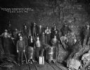
| Description: | Soon after the turn of the century, Joplin was named the lead and zinc capital of the world. A group of young men are shown mining underground. Caption rea... |

| Date: | |
|---|---|
| Description: | Soon after the turn of the century, Joplin was named the lead and zinc capital of the world. |
| Date: | |
|---|---|
| Description: | Soon after the turn of the century, Joplin was named the lead and zinc capital of the world. |

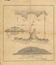
| Date: | 1858 |
|---|---|
| Description: | This 1858 map shows mine shafts, lead veins, and topography on the property of the New Diggings and Shullsburg Mining Company in Section 5 of Township 1 N.... |
| Date: | |
|---|---|
| Description: | The Mammoth and Standard Mining Mills has been producing silver, gold, lead, zinc and copper continuously since 1884. Caption reads: "Mammouth and Standard... |
| Date: | |
|---|---|
| Description: | Webb City was known as the world's largest and most productive lead and zinc mining field in the late 1800s and early 1900s and was part of the "Tri-State ... |
| Date: | |
|---|---|
| Description: | This map, based on an 1858 survey, shows the lead vein and the Western Wisconsin Mining Company's mine shafts in a section in the Town of New Diggings, Laf... |
| Date: | |
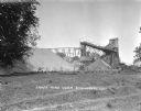
|---|---|
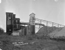
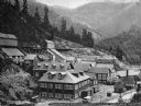
| Description: | Exterior view of James Mine with a field and fence in the foreground. Tram tracks lead from the tall building to large piles of rocks. There are steep stai... |
| Date: | |
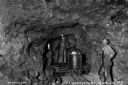
|---|---|
| Description: | Two miners in the interior of a mine. Soon after the turn of the century, Joplin was named the lead and zinc capital of the world. Caption reads: "Undergro... |

| Date: | |
|---|---|
| Description: | Soon after the turn of the century, Joplin was named the lead and zinc capital of the world. Elevated view of a man working with a hand jig. Caption reads:... |

| Date: | |
|---|---|
| Description: | Soon after the turn of the century, Joplin was named the lead and zinc capital of the world. A jig room is shown with a miner. Caption reads: "Typical Jig-... |

| Date: | 1805 |
|---|---|
| Description: | Map of the United States. It shows the states, cities, towns, Native American land, mountains, lakes, and rivers. Tennessee, Kentucky, and Ohio are labeled... |
If you didn't find the material you searched for, our Library Reference Staff can help.
Call our reference desk at 608-264-6535 or email us at: