Search: lead
Search: mines
Search: mining
Filter: Categories of Wisconsin Historical Images
Search: lead
Search: mines
Search: mining
Filter: Categories of Wisconsin Historical Images
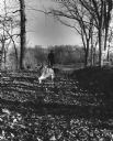
| Date: | 1960 |
|---|---|
| Description: | A man is running his dog on a trail in an old lead mining area. The trees are bare and fallen leaves are covering the ground. |

| Date: | 1888 |
|---|---|
| Description: | This is a reproduction of a map originally published in 1829 by R.W. Chandler, a pioneer settler of Galena. It is based on an earlier map by surveyor Luciu... |
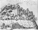
| Date: | 1900 |
|---|---|
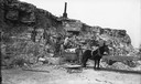
| Description: | View of the Gratiot homestead at Gratiot's Grove Site. |
| Date: | 1872 |
|---|---|
| Description: | Galena (lead sulfide) was melted at this open hearth furnace owned by Richard Straw and Company on the Roundtree Branch of the Little Platte River. The men... |
| Date: | |
|---|---|
| Description: | Miners and a mule work outside an iron mine near Mayville. |
| Date: | |
|---|---|
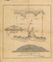
| Description: | This map, based on an 1858 survey, shows the lead vein and the Western Wisconsin Mining Company's mine shafts in a section in the Town of New Diggings, Laf... |
| Date: | |
|---|---|
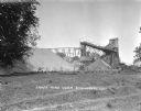
| Description: | Exterior view of James Mine with a field and fence in the foreground. Tram tracks lead from the tall building to large piles of rocks. There are steep stai... |
| Date: | |
|---|---|
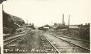
| Description: | View down railroad tracks that lead to industrial buildings and a smokestack. A caption on the image reads, "Zink (Zinc) Works, Mineral Point, Wis." |
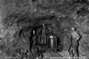
| Date: | |
|---|---|
| Description: | Two miners in the interior of a mine. Soon after the turn of the century, Joplin was named the lead and zinc capital of the world. Caption reads: "Undergro... |

| Date: | |
|---|---|
| Description: | Soon after the turn of the century, Joplin was named the lead and zinc capital of the world. Elevated view of a man working with a hand jig. Caption reads:... |

| Date: | |
|---|---|
| Description: | Soon after the turn of the century, Joplin was named the lead and zinc capital of the world. A jig room is shown with a miner. Caption reads: "Typical Jig-... |

| Date: | 1805 |
|---|---|
| Description: | Map of the United States. It shows the states, cities, towns, Native American land, mountains, lakes, and rivers. Tennessee, Kentucky, and Ohio are labeled... |
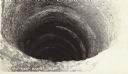
| Date: | |
|---|---|
| Description: | The 120 foot shot shaft below the shot tower at Tower Hill State Park. |
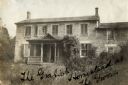
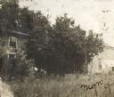
| Date: | 1900 |
|---|---|
| Description: | Exterior view of the Gratiot homestead at Gratiot's Grove Site. Handwriting on front reads: "The Gratiot Homestead at the (?)on." |

| Date: | 1866 |
|---|---|
| Description: | This map shows the location of county boundaries, cities, rivers, lakes, grant railroads, wagon roads, land office locations, iron, copper and lead deposit... |
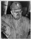
| Date: | |
|---|---|
| Description: | John L. Lewis, in miner's hat, after West Frankfort, Illinois, mine disaster. |

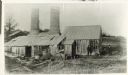
| Date: | 1948 |
|---|---|
| Description: | Large brick kiln-like structure in field. Built in 1876, the blast furnace was used to salvage additional lead from the slag of 18 area furnaces operating ... |
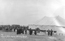
| Date: | 11 1909 |
|---|---|
| Description: | Photographic postcard of funeral and tent/morgue from the Cherry Mine disaster. Caption reads: "#37 Cherry Mine Horror Showing Morgue Dunham Photo Princeto... |

| Date: | 1867 |
|---|---|
| Description: | This 1867 manuscript map by Increase Lapham shows the topography and geology of the Blue Mounds region in the Town of Brigham in Iowa County and the towns ... |
If you didn't find the material you searched for, our Library Reference Staff can help.
Call our reference desk at 608-264-6535 or email us at: