Search: lead
Search: mines
Search: mining
Filter: Categories of Wisconsin Historical Images
Filter: Year of 1800-1899
Search: lead
Search: mines
Search: mining
Filter: Categories of Wisconsin Historical Images
Filter: Year of 1800-1899

| Date: | 1829 |
|---|---|
| Description: | Map of lead mines operating in Wisconsin. |
| Date: | 1850 |
|---|---|
| Description: | Blast furnace, also known as a Scotch hearth used in lead mining. |
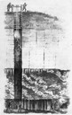
| Date: | 1844 |
|---|---|
| Description: | Cross section drawing of a Wisconsin lead mine. |
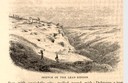
| Date: | 1853 |
|---|---|
| Description: | Engraved view of miners and hillside mines in the Lead Region. Caption reads: "Sketch of the Lead Region." |
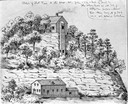
| Date: | 1853 |
|---|---|
| Description: | Engraved exterior view of a lead mining furnace. A man sits in a horse-drawn wagon at the left of the building. |

| Date: | 1829 |
|---|---|
| Description: | Photoprint of Crawford County lead district map. |

| Date: | 1829 |
|---|---|
| Description: | Cincinnati, Ohio, Ebr. Martin, engraver. |
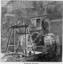
| Date: | 05 1866 |
|---|---|
| Description: | Engraved view of two men in a train locomotive observing the weighing of pig lead. Several bars of lead are stacked near the scale. |

| Date: | 1850 |
|---|---|
| Description: | Lithograph of a map drawn to indicate a mine on land owned by Mineral Point Mining Co. in the lead region of southwestern Wisconsin. |

| Date: | 1800 |
|---|---|
| Description: | Map of the United States. It shows the states, including Tennessee, cities, towns, Native American land, mountains, lakes, and rivers. Lead mines appear ju... |
| Date: | 05 1866 |
|---|---|
| Description: | Engraved exterior view of a smelting furnace with a small group of men with horses gathered in front. |

| Date: | 1858 |
|---|---|
| Description: | This 1858 map shows mine shafts, lead veins, and topography on the property of the New Diggings and Shullsburg Mining Company in Section 5 of Township 1 N.... |

| Date: | 1888 |
|---|---|
| Description: | This is a reproduction of a map originally published in 1829 by R.W. Chandler, a pioneer settler of Galena. It is based on an earlier map by surveyor Luciu... |
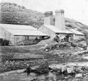
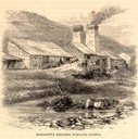
| Date: | 1872 |
|---|---|
| Description: | Galena (lead sulfide) was melted at this open hearth furnace owned by Richard Straw and Company on the Roundtree Branch of the Little Platte River. The men... |

| Date: | 1805 |
|---|---|
| Description: | Map of the United States. It shows the states, cities, towns, Native American land, mountains, lakes, and rivers. Tennessee, Kentucky, and Ohio are labeled... |

| Date: | 1866 |
|---|---|
| Description: | This map shows the location of county boundaries, cities, rivers, lakes, grant railroads, wagon roads, land office locations, iron, copper and lead deposit... |

| Date: | 1867 |
|---|---|
| Description: | This 1867 manuscript map by Increase Lapham shows the topography and geology of the Blue Mounds region in the Town of Brigham in Iowa County and the towns ... |

| Date: | 1871 |
|---|---|
| Description: | This map shows railroads, canals, towns and some lighthouses. Areas of the company lands proper, tin, iron, gold & silver, silver islet, and lead are color... |
If you didn't find the material you searched for, our Library Reference Staff can help.
Call our reference desk at 608-264-6535 or email us at: