Search: lead
Search: mines
Filter: Categories of Wisconsin Historical Images
Filter: County of Iowa
Search: lead
Search: mines
Filter: Categories of Wisconsin Historical Images
Filter: County of Iowa

| Date: | 1836 |
|---|---|
| Description: | This early to mid-19th century map shows the township and range system, sections, landownership, furnaces, lead mines, copper mines, and roads in the vicin... |

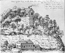
| Date: | 1850 |
|---|---|
| Description: | Lithograph of a map drawn to indicate a mine on land owned by Mineral Point Mining Co. in the lead region of southwestern Wisconsin. |
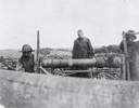
| Date: | |
|---|---|
| Description: | An unidentified mining scene where two men are cranking a windlass, common only in early lead and zinc mining in southwest Wisconsin. The windlass was used... |

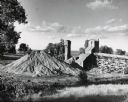
| Date: | 1948 |
|---|---|
| Description: | Large brick kiln-like structure in field. Built in 1876, the blast furnace was used to salvage additional lead from the slag of 18 area furnaces operating ... |
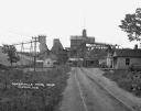
| Date: | 1925 |
|---|---|
| Description: | View down road leading up to the Cokerville Mine. Two horses pulling a wagon are near the road, and automobiles are parked on the right near a building wit... |
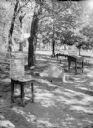
| Date: | 1925 |
|---|---|
| Description: | An outdoor exhibit, possibly at Tower Hill State Park, with a display featuring a "pig of lead" found near the shot tower there. There is also a bronze pla... |
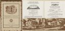
| Date: | 1935 |
|---|---|
| Description: | Menu of Cornish pasties and desserts offered by Pendarvis House, a group of restored stone houses built by Cornish settlers in Mineral Point. The cover of ... |
If you didn't find the material you searched for, our Library Reference Staff can help.
Call our reference desk at 608-264-6535 or email us at: