Search: lead
Search: mining
Filter: Categories of Wisconsin Historical Images
Filter: County of Lafayette
Search: lead
Search: mining
Filter: Categories of Wisconsin Historical Images
Filter: County of Lafayette

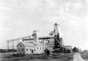
| Date: | 1936 |
|---|---|
| Description: | View from road of lead and zinc mines and surrounding buildings. |
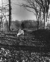
| Date: | 1960 |
|---|---|
| Description: | A man is running his dog on a trail in an old lead mining area. The trees are bare and fallen leaves are covering the ground. |

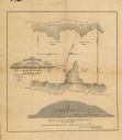
| Date: | 1858 |
|---|---|
| Description: | This 1858 map shows mine shafts, lead veins, and topography on the property of the New Diggings and Shullsburg Mining Company in Section 5 of Township 1 N.... |
| Date: | 1900 |
|---|---|
| Description: | View of the Gratiot homestead at Gratiot's Grove Site. |
| Date: | |
|---|---|
| Description: | This map, based on an 1858 survey, shows the lead vein and the Western Wisconsin Mining Company's mine shafts in a section in the Town of New Diggings, Laf... |
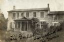
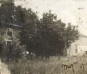
| Date: | 1900 |
|---|---|
| Description: | Exterior view of the Gratiot homestead at Gratiot's Grove Site. Handwriting on front reads: "The Gratiot Homestead at the (?)on." |
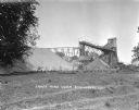
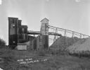
| Date: | |
|---|---|
| Description: | Exterior view of James Mine with a field and fence in the foreground. Tram tracks lead from the tall building to large piles of rocks. There are steep stai... |
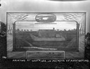
| Date: | 1925 |
|---|---|
| Description: | Painting of Fort Hamilton propped outdoors on a woodpile. An oval inset painting at the top commemorates is titled: "Col. Hamilton Leaving For The Gold Fie... |
If you didn't find the material you searched for, our Library Reference Staff can help.
Call our reference desk at 608-264-6535 or email us at: