Search: lead
Search: mining
Filter: Categories of Wisconsin Historical Images
Search: lead
Search: mining
Filter: Categories of Wisconsin Historical Images
| Date: | |
|---|---|
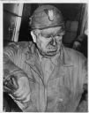
| Description: | John L. Lewis, in miner's hat, after West Frankfort, Illinois, mine disaster. |
| Date: | 1925 |
|---|---|
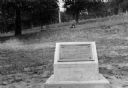
| Description: | View of a marker commemorating Old Helena. |
| Date: | 11 1909 |
|---|---|
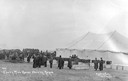
| Description: | Photographic postcard of funeral and tent/morgue from the Cherry Mine disaster. Caption reads: "#37 Cherry Mine Horror Showing Morgue Dunham Photo Princeto... |

| Date: | 1805 |
|---|---|
| Description: | Map of the United States. It shows the states, cities, towns, Native American land, mountains, lakes, and rivers. Tennessee, Kentucky, and Ohio are labeled... |

| Date: | 1867 |
|---|---|
| Description: | This 1867 manuscript map by Increase Lapham shows the topography and geology of the Blue Mounds region in the Town of Brigham in Iowa County and the towns ... |

| Date: | 1871 |
|---|---|
| Description: | This map shows railroads, canals, towns and some lighthouses. Areas of the company lands proper, tin, iron, gold & silver, silver islet, and lead are color... |
| Date: | 1925 |
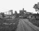
|---|---|
| Description: | View down road leading up to the Cokerville Mine. Two horses pulling a wagon are near the road, and automobiles are parked on the right near a building wit... |
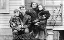
| Date: | 11 1909 |
|---|---|
| Description: | Group portrait of a family. Caption reads: "W.H. Clelland and Family. One of the Cherry Mine survivers [sic]. It is this man who was said to have le... |

| Date: | 1872 |
|---|---|
| Description: | This map, which includes eastern Iowa, northern Illinois and a portion of Michigan's Upper peninsula, shows the township survey grid and identifies countie... |
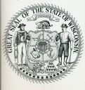
| Date: | |
|---|---|
| Description: | Black and white drawing of the great seal of the state of Wisconsin. A mariner and a miner stand on either side of a quartered shield topped by a badger an... |
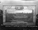
| Date: | 1948 |
|---|---|
| Description: | Center panel of the completed mural at the Wisconsin Historical Society. The image depicts wheat farming, one of the state's earliest and largest industrie... |
| Date: | 1925 |
|---|---|
| Description: | Painting of Fort Hamilton propped outdoors on a woodpile. An oval inset painting at the top commemorates is titled: "Col. Hamilton Leaving For The Gold Fie... |

| Date: | 1835 |
|---|---|
| Description: | Plat for a proposed Sinsinawa City (never built), in Grant County, Wis. When it became clear in the mid-1830s that Wisconsin Territory would be established... |

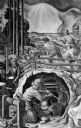
| Date: | |
|---|---|
| Description: | Stereograph of the interior view of a factory. Machinery, materials, gantries, chain hoists, chains, cables, line shafts, and equipment fill the structure.... |
If you didn't find the material you searched for, our Library Reference Staff can help.
Call our reference desk at 608-264-6535 or email us at: