 Search: menominee
Filter: Community of Milwaukee
Filter: Creator Name of Unknown
Search: menominee
Filter: Community of Milwaukee
Filter: Creator Name of Unknown
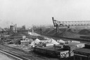
| Date: | 1940 |
|---|---|
| Description: | An industrial area of Milwaukee known as Menominee Valley. |

| Date: | 1942 |
|---|---|
| Description: | This photostat map shows roads, ferry, impassible marsh land, the Menominee River, the Milwaukee River, and Lake Michigan. |

| Date: | 1862 |
|---|---|
| Description: | Drawn the second year of the Civil War, this 1862 map of Milwaukee shows post offices, light houses, beacon lights, county buildings, elevator warehouses, ... |
If you didn't find the material you searched for, our Library Reference Staff can help.
Call our reference desk at 608-264-6535 or email us at: