 Search: menominee
Filter: County of Milwaukee
Search: menominee
Filter: County of Milwaukee
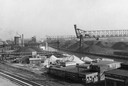
| Date: | 1940 |
|---|---|
| Description: | An industrial area of Milwaukee known as Menominee Valley. |

| Date: | 11 05 1913 |
|---|---|
| Description: | Text on the front reads: "The Menominee, Wauwatosa, Wis." The Menominee River flowing through a park-like area. The right bank appears eroded, the left ban... |
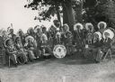
| Date: | |
|---|---|
| Description: | A group portrait of a band of Menominee Indians posing with their instruments. They are wearing feather headdresses. |
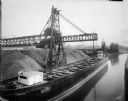
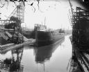
| Date: | 07 25 1914 |
|---|---|
| Description: | The Gilchrist Transportation Company cargo ship "Tyrone" transports coal on the Menominee River. |
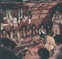
| Date: | 1936 |
|---|---|
| Description: | Actors in Indian costume as seen in the film "Mishaskwut," which depicts the life of the Menominee Indians. The film was sponsored by the Wauwatosa Board o... |
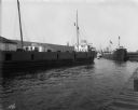
| Date: | 07 17 1914 |
|---|---|
| Description: | Steamboat "E.L. Wallace" on the Menominee River looking east from the 16th Street viaduct. Coal yards are on the banks of the harbor. |
| Date: | 1919 |
|---|---|
| Description: | A large, coal cargo ship docks in the harbor in Menominee Valley. |
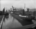
| Date: | 08 09 1914 |
|---|---|
| Description: | Erie Railroad Lake Line cargo ships transport coal on the Menominee River, west of the Water Street Bridge. |
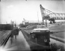
| Date: | 07 17 1914 |
|---|---|
| Description: | Menominee River coal yards, west from the 16th Street viaduct. There is a cargo ship called the "John B. Cowle" in the harbor between two coal yards. Worke... |

| Ship Master: | Captain McCormick |
|---|---|
| Nearby City: | Milwaukee, Milwaukee County |
| Body of water: | Menominee River |

| Date: | 1927-03-28 |
|---|---|
| County: | Milwaukee |
| City: | Milwaukee |

| Date: | 1942 |
|---|---|
| Description: | This photostat map shows roads, ferry, impassible marsh land, the Menominee River, the Milwaukee River, and Lake Michigan. |
| Date: | 1923-02-26 |
|---|---|
| County: | Milwaukee |
| City: | Milwaukee |
| Date: | 1925-02-22 |
|---|---|
| County: | Milwaukee |
| City: | Milwaukee |

| Date: | 08 27 1910 |
|---|---|
| Description: | Looking south towards the 16th Street viaduct over Menominee Valley from about Clybourn Street. Shows the surrounding industrial area and neighborhoods. Se... |

| Date: | 2000 |
|---|---|
| Description: | This map shows the industrial area along the Menominee River and canals. Industrial buildings are shown in orange and labeled in red. Other areas are shown... |
| Date: | 1898-08-30 |
|---|---|
| County: | Milwaukee |
| City: | Milwaukee |
| Date: | 1934-10-25 |
|---|---|
| County: | Milwaukee |
| City: | Milwaukee |
If you didn't find the material you searched for, our Library Reference Staff can help.
Call our reference desk at 608-264-6535 or email us at: