 Search: menominee
Filter: Subject of human settlements
Search: menominee
Filter: Subject of human settlements
| Date: | 1910 |
|---|---|
| Description: | A crew of men crushing rock for Senator James H. Stout's improved highway. |

| Date: | 1910 |
|---|---|
| Description: | This map of northeastern Wisconsin shows the township grid, counties, cities and villages, lakes, rivers, rail lines and the Menominee Indian Reservation. ... |

| Date: | 1956 |
|---|---|
| Description: | This map shows reservation boundaries, U.S. township lines, highways, roads, rivers, and lakes. The lower left corner of the map includes a legend of "Conv... |

| Date: | 1914 |
|---|---|
| Description: | This map shows township grids, railroads, roads, and drainage. The area of the map covers northeastern Wisconsin and Menominee Indian reservation. Green Ba... |
| Date: | |
|---|---|
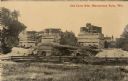
| Description: | View of nonoperational lime kilns. Caption reads: "Old Lime Kiln, Menominee Falls, Wis." |

| Date: | 1857 |
|---|---|
| Description: | A map of the state of Wisconsin and the southeastern portion of the Territory of Minnesota, showing the Wisconsin reservations of the Oneida, Menominee, St... |

| Date: | 1947 |
|---|---|
| Description: | Shows lot and block numbers, 28 points of interest in the upper left that correspond to numbers on the map, and landownership with acreages. "Erickson Brot... |
| Date: | 1912 |
|---|---|
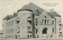
| Description: | The Mabel Tainter Memorial building designed by Harvey Ellis. Caption reads: "Mabel Tainter Memorial, Menominee, Wis." |
| Date: | 11 02 1912 |
|---|---|
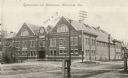
| Description: | View across unpaved road towards the gymnasium and natatorium. Caption reads: "Gymnasium and Natatorium, Menominee, Wis." |

| Date: | 1909 |
|---|---|
| Description: | View of a boating scene off of the shore of Marinette and Menominee. Two boys are walking on the pier on the left, and a crowd of people are gathered at th... |

| Date: | |
|---|---|
| Description: | View across field of a round barn with cows grazing in the pasture in front. Built by John Warren, Menominee. |
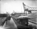
| Date: | 08 09 1914 |
|---|---|
| Description: | Erie Railroad Lake Line cargo ships transport coal on the Menominee River, west of the Water Street Bridge. |

| Date: | 1920 |
|---|---|
| Description: | This map shows a small island in the Menominee River and includes a survey table and certification. |
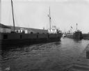
| Date: | 07 17 1914 |
|---|---|
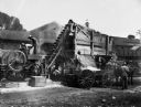
| Description: | Menominee River coal yards, west from the 16th Street viaduct. There is a cargo ship called the "John B. Cowle" in the harbor between two coal yards. Worke... |
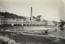
| Date: | |
|---|---|
| Description: | The Menominee River and paper mill as photographed by William A. Hotchkiss for the Wisconsin Good Roads Association. |
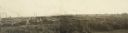
| Date: | 1910 |
|---|---|
| Description: | Panoramic view of lumber yards and sawmills. Telephone poles have been touched out in lower left of foreground. |

| Date: | 1933 |
|---|---|
| Description: | This map shows the township and range system, sections, cities and villages, schools, roads, railroads, and lakes and streams in Shawano County, which at t... |

| Date: | 1960 |
|---|---|
| Description: | This map shows lot and block numbers, additions, and rural acreages and includes an index of rail roads, industrial plants, Dunn County and Menominee owned... |

| Date: | 1942 |
|---|---|
| Description: | This photostat map shows roads, ferry, impassible marsh land, the Menominee River, the Milwaukee River, and Lake Michigan. |
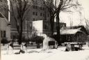
| Date: | 1920 |
|---|---|
| Description: | View of the memorial to Camp Bragg, with a tablet, located in Menominee Park. It is surrounded by Civil War cannons. Snow is on the ground, and buildings a... |
If you didn't find the material you searched for, our Library Reference Staff can help.
Call our reference desk at 608-264-6535 or email us at: