Search: menominee
Filter: Subject of human settlements
Search: menominee
Filter: Subject of human settlements
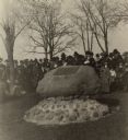
| Date: | 1921 |
|---|---|
| Description: | The Allouez Monument, located in Menominee Park. A large group of people are gathered around the monument. The monument marks the place where Father Claude... |
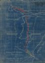
| Date: | 1923 |
|---|---|
| Description: | This blueprint map shows Wisconsin and Michigan-owned railroad and trackage rights from Iron Mountain to Menominee, Michigan, as well as other railroads. W... |

| Date: | 1917 |
|---|---|
| Description: | View of a road bridge crossing the Menominee River. There is a paper mill on the opposite shoreline. Caption reads: "Hattie Street Bridge and M. & M. Paper... |
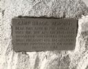
| Date: | 1920 |
|---|---|
| Description: | Close-up of the plaque on the memorial to Camp Bragg, located in Menominee Park. It reads: "Camp Bragg Memorial Near this spot in the autumn of 1862 the 21... |

| Date: | 08 27 1910 |
|---|---|
| Description: | Looking south towards the 16th Street viaduct over Menominee Valley from about Clybourn Street. Shows the surrounding industrial area and neighborhoods. Se... |

| Date: | |
|---|---|
| Description: | "Peavy Falls Group" of men and boys posed on bank of river. There is a man in a canoe in the river, and a footbridge in the background. |

| Date: | 1851 |
|---|---|
| Description: | This manuscript map of the southern portion of the Town of Porterfield, Marinette County, Wisconsin, shows sections and land ownership. The Menominee River... |

| Date: | 1887 |
|---|---|
| Description: | This manuscript map of the southern portion of the Town of Porterfield, Marinette County, Wisconsin, shows sections and land ownership. The Menominee River... |

| Date: | 2000 |
|---|---|
| Description: | This map shows the industrial area along the Menominee River and canals. Industrial buildings are shown in orange and labeled in red. Other areas are shown... |

| Date: | 10 21 1855 |
|---|---|
| Description: | Map of the Wisconsin and the Minnesota Territory showing the status of township surveys in Wisconsin and southeastern Minnesota. The Wisconsin reservation... |

| Date: | 1902 |
|---|---|
| Description: | This map shows the railroads of southern Wisconsin with the routes of the Chicago, Milwaukee, and St. Paul Railway traced in red. The township grid, counti... |

| Date: | 1874 |
|---|---|
| Description: | This hand-colored map shows the railroads "completed" "in progress" and "contemplated" rivers, counties, cities and villages, and named towns in the state,... |
| Date: | |
|---|---|
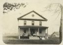
| Description: | Exterior of Keshena Boardinghouse with a group of men, women and children positioned on the front porch. |

| Date: | 1846 |
|---|---|
| Description: | A map of Wisconsin and a portion of Minnesota that show the township surveys in progress in portions of the Saint Croix River region and in central Wiscons... |
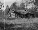
| Date: | 09 17 1961 |
|---|---|
| Description: | A broken down, abandoned log shack on the Stockbridge Indian Reservation. |
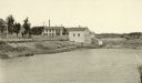
| Date: | 1887 |
|---|---|
| Description: | View of the boom company office and the site of the old trading post. |

| Date: | 1887 |
|---|---|
| Description: | Mill workers in the yard at Ramsay & Jones Mill. |

| Date: | 1887 |
|---|---|
| Description: | The Ramsay & Jones Mill with logs in the water in the foreground. |

| Date: | 1855 |
|---|---|
| Description: | This Wisconsin map depicts counties, creeks, rivers, lakes, railroads completed, railroads in progress, common roads and the Menomonee Reservation. |
If you didn't find the material you searched for, our Library Reference Staff can help.
Call our reference desk at 608-264-6535 or email us at: