 Search: menominee
Filter: Subject of human settlements
Filter: Year of 1800-1899
Search: menominee
Filter: Subject of human settlements
Filter: Year of 1800-1899

| Date: | 1887 |
|---|---|
| Description: | A bird's-eye map of Menekaune, Menominee and Marinette. |

| Date: | 1887 |
|---|---|
| Description: | The bay shore of Menominee filled with driftwood. |
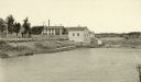
| Date: | 1887 |
|---|---|
| Description: | A view at the mouth of the Menominee River showing Ludington Wells and Van Schaick's mills. |
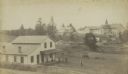
| Date: | 1890 |
|---|---|
| Description: | Farmer's house with rear of the government Contract School on the Menominee reservation in the distance. The Keshena Creek flows between the farmhouse and ... |

| Date: | 1857 |
|---|---|
| Description: | A map of the state of Wisconsin and the southeastern portion of the Territory of Minnesota, showing the Wisconsin reservations of the Oneida, Menominee, St... |

| Date: | 1851 |
|---|---|
| Description: | This manuscript map of the southern portion of the Town of Porterfield, Marinette County, Wisconsin, shows sections and land ownership. The Menominee River... |

| Date: | 1887 |
|---|---|
| Description: | This manuscript map of the southern portion of the Town of Porterfield, Marinette County, Wisconsin, shows sections and land ownership. The Menominee River... |

| Date: | 10 21 1855 |
|---|---|
| Description: | Map of the Wisconsin and the Minnesota Territory showing the status of township surveys in Wisconsin and southeastern Minnesota. The Wisconsin reservation... |

| Date: | 1874 |
|---|---|
| Description: | This hand-colored map shows the railroads "completed" "in progress" and "contemplated" rivers, counties, cities and villages, and named towns in the state,... |

| Date: | 1846 |
|---|---|
| Description: | A map of Wisconsin and a portion of Minnesota that show the township surveys in progress in portions of the Saint Croix River region and in central Wiscons... |
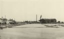
| Date: | 1887 |
|---|---|
| Description: | View of the boom company office and the site of the old trading post. |

| Date: | 1887 |
|---|---|
| Description: | Mill workers in the yard at Ramsay & Jones Mill. |

| Date: | 1887 |
|---|---|
| Description: | The Ramsay & Jones Mill with logs in the water in the foreground. |

| Date: | 1855 |
|---|---|
| Description: | This Wisconsin map depicts counties, creeks, rivers, lakes, railroads completed, railroads in progress, common roads and the Menomonee Reservation. |

| Date: | 1855 |
|---|---|
| Description: | This map depicts counties, creeks, rivers, lakes, railroads completed, railroads in progress, common roads and the Menomonee Reservation. |

| Date: | 1862 |
|---|---|
| Description: | Drawn the second year of the Civil War, this 1862 map of Milwaukee shows post offices, light houses, beacon lights, county buildings, elevator warehouses, ... |

| Date: | 1887 |
|---|---|
| Description: | Elevated view of Marinette looking toward the mouth of the river from the tower of City Hall. Fences, fields, and industrial buildings are in the foregroun... |

| Date: | 1855 |
|---|---|
| Description: | This map shows the entire state and part of the Upper Peninsula of Michigan. It depicts creeks, rivers, lakes, railroads completed, railroads in progress, ... |

| Date: | 1857 |
|---|---|
| Description: | This map depicts the township survey grid and identifies counties, named towns, cities and villages, rivers, lakes, railroads, roads, and the Menomonee and... |

| Date: | 1858 |
|---|---|
| Description: | This map of the entire state of Wisconsin depicts the township survey grid and identifies counties, named towns, cities and villages, rivers, lakes, railro... |
If you didn't find the material you searched for, our Library Reference Staff can help.
Call our reference desk at 608-264-6535 or email us at: