 Search: menominee
Filter: Year of 1800-1899
Filter: Categories of Wisconsin Historical Images
Search: menominee
Filter: Year of 1800-1899
Filter: Categories of Wisconsin Historical Images

| Date: | 1887 |
|---|---|
| Description: | A bird's-eye map of Menekaune, Menominee and Marinette. |

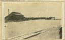
| Date: | 1887 |
|---|---|
| Description: | The bay shore of Menominee filled with driftwood. |
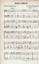
| Date: | 1855 |
|---|---|
| Description: | A page of Menominee Indian music as transcribed by Father Florimond Bonduel. |
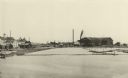
| Date: | 1887 |
|---|---|
| Description: | A view at the mouth of the Menominee River showing Ludington Wells and Van Schaick's mills. |
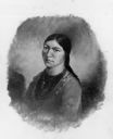
| Date: | 1845 |
|---|---|
| Description: | Menominee woman, Iwa-toke, "The Serpent," sister to Ke-wah-ten, "The North Wind." |
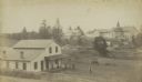
| Date: | 1890 |
|---|---|
| Description: | Farmer's house with rear of the government Contract School on the Menominee reservation in the distance. The Keshena Creek flows between the farmhouse and ... |
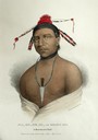
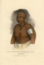
| Date: | 1835 |
|---|---|
| Description: | Ma-ko-me-ta or Bear's Oil, a Monomonie (Menominee) Chief. Hand-colored lithograph from the Aboriginal Portfolio, sketched at the treaty of Green Bay (1827)... |
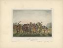
| Date: | 1842 |
|---|---|
| Description: | Menominee war dance, as depicted by Francois, Comte de Castelnau, a French naturalist and diplomat who visited Green Bay, Wisconsin about 1838. This detail... |
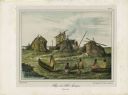
| Date: | 1842 |
|---|---|
| Description: | A Menominee village as depicted by Francois, Comte de Castelnau, a French naturalist and diplomat who visited the Green Bay area about 1838. The detailed, ... |
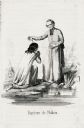
| Date: | 1855 |
|---|---|
| Description: | Illustration of Father Florimond Bonduel baptizing a Menominee woman named Nakam by pouring water from a clam shell onto her head. The woman is kneeling at... |
| Date: | 07 30 1865 |
|---|---|
| Description: | An exterior view across water of Robert Stephenson & Company Mill, which was a steam mill. |

| Date: | 1857 |
|---|---|
| Description: | A map of the state of Wisconsin and the southeastern portion of the Territory of Minnesota, showing the Wisconsin reservations of the Oneida, Menominee, St... |
| Date: | 1835 |
|---|---|
| Description: | Ma-che-ka-kat, or the Bad Hawk, a Chief of the Monomonie (Menominee) Tribe. Hand-colored lithograph from the Aboriginal Portfolio, painted at the Treaty of... |
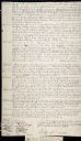
| Date: | 08 19 1825 |
|---|---|
| Description: | Beginning page of the Treaty between the United States and the Chippewa, Sauk, Fox, Menominee, Iowa, Sioux, Winnebago and a portion of the Ottawa, Chippewa... |
| Date: | 08 19 1825 |
|---|---|
| Description: | Fourth page of the Treaty between the United States and the Chippewa, Sauk, Fox, Menominee, Iowa, Sioux, Winnebago and a portion of the Ottawa, Chippewa, a... |
| Date: | 08 19 1825 |
|---|---|
| Description: | Second page of the Treaty between the United States and the Chippewa, Sauk, Fox, Menominee, Iowa, Sioux, Winnebago and a portion of the Ottawa, Chippewa, a... |
| Date: | 08 19 1825 |
|---|---|
| Description: | Third page of the Treaty between the United States and the Chippewa, Sauk, Fox, Menominee, Iowa, Sioux, Winnebago and a portion of the Ottawa, Chippewa, an... |
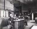
| Date: | 1898 |
|---|---|
| Description: | Interior of the Knapp, Stout & Co. lumber mill office with posed members of the staff. On the desk in the center of the room is a device with an earpiece h... |

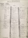
| Date: | 1851 |
|---|---|
| Description: | This manuscript map of the southern portion of the Town of Porterfield, Marinette County, Wisconsin, shows sections and land ownership. The Menominee River... |

| Date: | 1887 |
|---|---|
| Description: | This manuscript map of the southern portion of the Town of Porterfield, Marinette County, Wisconsin, shows sections and land ownership. The Menominee River... |
If you didn't find the material you searched for, our Library Reference Staff can help.
Call our reference desk at 608-264-6535 or email us at: