 Search: menominee
Filter: Year of 1800-1899
Filter: Year of 1850-1859
Search: menominee
Filter: Year of 1800-1899
Filter: Year of 1850-1859
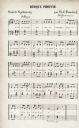
| Date: | 1855 |
|---|---|
| Description: | A page of Menominee Indian music as transcribed by Father Florimond Bonduel. |
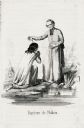
| Date: | 1855 |
|---|---|
| Description: | Illustration of Father Florimond Bonduel baptizing a Menominee woman named Nakam by pouring water from a clam shell onto her head. The woman is kneeling at... |

| Date: | 1857 |
|---|---|
| Description: | A map of the state of Wisconsin and the southeastern portion of the Territory of Minnesota, showing the Wisconsin reservations of the Oneida, Menominee, St... |

| Learn about a case that created much racial tension between white settlers and the Menominee Indians. This article includes a link to a longer article. |
| Chief of the Menominee Indians |
|---|
| Biography of Menominee Indian chief Oshkosh. |

| Date: | 1851 |
|---|---|
| Description: | This manuscript map of the southern portion of the Town of Porterfield, Marinette County, Wisconsin, shows sections and land ownership. The Menominee River... |

| Date: | 10 21 1855 |
|---|---|
| Description: | Map of the Wisconsin and the Minnesota Territory showing the status of township surveys in Wisconsin and southeastern Minnesota. The Wisconsin reservation... |
| Menominee War Chief |
|---|
| Learn about the leadership of this Menominee War Chief and his negotiations with the U.S. Commissioner of Indian Affairs. |

| Location: | Run aground on Green Island, Green Bay, Lake Michigan. |
|---|---|
| Nearby City: | Marinette, Marinette County |
| Body of water: | Green Bay |

| Date: | 1858 |
|---|---|
| Description: | A survey map that shows the status of township surveys in Wisconsin. At that point, the majority of the state had been surveyed and platted, with the area... |

| Date: | 1855 |
|---|---|
| Description: | This Wisconsin map depicts counties, creeks, rivers, lakes, railroads completed, railroads in progress, common roads and the Menomonee Reservation. |

| Date: | 1855 |
|---|---|
| Description: | This map depicts counties, creeks, rivers, lakes, railroads completed, railroads in progress, common roads and the Menomonee Reservation. |

| Date: | 1851 |
|---|---|
| Description: | A survey map of Wisconsin and eastern Minnesota, with the township surveys for portions of the Saint Croix region in progress. The maps also show the Meno... |

| Date: | 1855 |
|---|---|
| Description: | This map shows the entire state and part of the Upper Peninsula of Michigan. It depicts creeks, rivers, lakes, railroads completed, railroads in progress, ... |

| Date: | 1857 |
|---|---|
| Description: | This map depicts the township survey grid and identifies counties, named towns, cities and villages, rivers, lakes, railroads, roads, and the Menomonee and... |

| Date: | 1858 |
|---|---|
| Description: | This map of the entire state of Wisconsin depicts the township survey grid and identifies counties, named towns, cities and villages, rivers, lakes, railro... |
If you didn't find the material you searched for, our Library Reference Staff can help.
Call our reference desk at 608-264-6535 or email us at:
