 Search: menominee
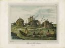
| Date: | 1842 |
|---|---|
| Description: | A Menominee village as depicted by Francois, Comte de Castelnau, a French naturalist and diplomat who visited the Green Bay area about 1838. The detailed, ... |
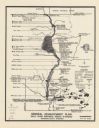
| Date: | 1974 |
|---|---|
| Description: | This map is a 9 part map detailing various parts of Menominee County, Wisconsin. Page 1 of the map shows federal aid control in the county and was used by ... |

| Date: | 1871-03-18 |
|---|---|
| County: | Marinette |
| City: | Marinette |
| Date: | 1921-04-25 |
|---|---|
| County: | Winnebago |
| City: | Oshkosh |
| Date: | 1933-03-23 |
|---|---|
| County: | Menominee |
| City: |
| Date: | 1931-03-18 |
|---|---|
| County: | Menominee |
| City: |
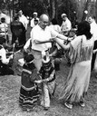
| Date: | 1942 |
|---|---|
| Description: | A Menominee ceremonial dance. The dancers are wearing Native American ceremonial dress. Although Roman Catholic missions had banned many Native American ce... |
| Date: | 1959 |
|---|---|
| Description: | Wisconsin State Senator Alfred A. Laun (R.) of Kiel, participating in what appears to be a square dance with Menominee Indians and others. This image is pa... |
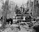
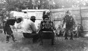
| Date: | |
|---|---|
| Description: | Group of twelve men and one woman posed with a load of logs waiting to be pulled by two horses harnessed to a sled. Several of the men hold cant hooks or p... |
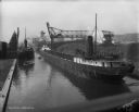
| Date: | 1919 |
|---|---|
| Description: | A large, coal cargo ship docks in the harbor in Menominee Valley. |

| Date: | 1906 |
|---|---|
| Description: | This map shows streets, railroads, land use, public buildings, commercial businesses, and the Menominee River. Depths are shown by gradient tints and sound... |
| Community: | Williams Bay |
|---|---|
| County: | Walworth |
| Historic Name: | |
| Reference Number: | 82946 |

| Community: | Williams Bay |
|---|---|
| County: | Walworth |
| Historic Name: | |
| Reference Number: | 82957 |
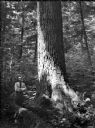
| Date: | 07 1936 |
|---|---|
| Description: | Ray Weber standing next to a large white pine on a Menominee Indian reservation. |
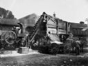
| Date: | 1910 |
|---|---|
| Description: | A crew of men crushing rock for Senator James H. Stout's improved highway. |

| Date: | 1910 |
|---|---|
| Description: | This map of northeastern Wisconsin shows the township grid, counties, cities and villages, lakes, rivers, rail lines and the Menominee Indian Reservation. ... |

| Date: | 1958 |
|---|---|
| Description: | Image is an outdoor portrait of a performer wearing a fringed vest, beaded necklace and headdress, and holding a small axe. Member of the Peavey Falls grou... |
| Community: | Williams Bay |
|---|---|
| County: | Walworth |
| Historic Name: | |
| Reference Number: | 82947 |
If you didn't find the material you searched for, our Library Reference Staff can help.
Call our reference desk at 608-264-6535 or email us at:
