 Search: menominee

| Date: | |
|---|---|
| Description: | Photographic postcard of Smoky Falls, now called Big Smokey Falls and found within the Menominee Nation. A boy is standing on the left near the falls. |

| Date: | 1956 |
|---|---|
| Description: | This map shows reservation boundaries, U.S. township lines, highways, roads, rivers, and lakes. The lower left corner of the map includes a legend of "Conv... |

| Date: | 1914 |
|---|---|
| Description: | This map shows township grids, railroads, roads, and drainage. The area of the map covers northeastern Wisconsin and Menominee Indian reservation. Green Ba... |
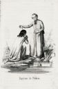
| Date: | 1855 |
|---|---|
| Description: | Illustration of Father Florimond Bonduel baptizing a Menominee woman named Nakam by pouring water from a clam shell onto her head. The woman is kneeling at... |
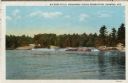
| Date: | 1953 |
|---|---|
| Description: | View upriver across water towards the Big Eddy Falls on the Wolf River. A group of people are standing on the right bank. Caption reads: "Big Eddy Falls, M... |
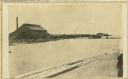
| Date: | 07 30 1865 |
|---|---|
| Description: | An exterior view across water of Robert Stephenson & Company Mill, which was a steam mill. |
| Community: | Williams Bay |
|---|---|
| County: | Walworth |
| Historic Name: | |
| Reference Number: | 82947 |

| Date: | 1925-05-11 |
|---|---|
| County: | Shawano |
| City: |

| Date: | 2016 |
|---|---|
| Description: | A beaded dance bag, which was once presented to General J.C. Starkweather by a Menominee Indian. |
| Date: | |
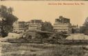
|---|---|
| Description: | View of nonoperational lime kilns. Caption reads: "Old Lime Kiln, Menominee Falls, Wis." |

| Nearby City: | Bayfield, Bayfield County |
|---|---|
| Body of water: | Lake Superior |
| Community: | Williams Bay |
|---|---|
| County: | Walworth |
| Historic Name: | |
| Reference Number: | 82945 |
| Date: | 1915-11-23 |
|---|---|
| County: | Dunn |
| City: | Menomonie |

| Date: | 1857 |
|---|---|
| Description: | A map of the state of Wisconsin and the southeastern portion of the Territory of Minnesota, showing the Wisconsin reservations of the Oneida, Menominee, St... |

| Date: | 1936 |
|---|---|
| Description: | Loading a large white pine log cut on the Menominee Indian Reservation onto a truck. The log was hauled to the Wisconsin State Fair for a display about the... |
| Date: | 1936 |
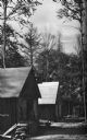
|---|---|
| Description: | Exterior view of a logging camp on the Menominee Indian Reservation. The three buildings are surrounded by forest. |

| Date: | 1952 |
|---|---|
| Description: | This map shows counties, towns, cities, and selected villages, as well as the Menominee Indian Reservation are identified on this U.S. Post Office. Circles... |

| Date: | 1947 |
|---|---|
| Description: | Shows lot and block numbers, 28 points of interest in the upper left that correspond to numbers on the map, and landownership with acreages. "Erickson Brot... |
If you didn't find the material you searched for, our Library Reference Staff can help.
Call our reference desk at 608-264-6535 or email us at:
